

The High Moor Region of the Lake Egelsee from Stockwinkl to Unterach


- All weather
- Suitable for families
Interactive elevation profile
Create PDF
Tour-Details
Path number: 3
Starting place: 4866 Unterach am Attersee
Destination: 4866 Unterach am Attersee
duration: 2h 13m
length: 6,8 km
Altitude difference (uphill): 262m
Altitude difference (downhill): 275m
Lowest point: 473m
Highest point: 669m
difficulty: medium
condition: medium
panoramic view: Great panorama
Paths covering:
Asphalt, Gravel, Hiking trail
powered by TOURDATA
roadblock: Closure in the area of the former fairytale hiking trail
Description: Due to the danger of falling branches, the area of the former fairytale hiking trail is closed until further notice.
The High Moor Region of the Lake Egelsee from Stockwinkl to Unterach
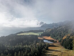
Starting at the Stockwinkel shipping pier, follow the Attersee State Road uphill to the Egelsee natural reserve. Continue onwards to the "Druckerhof" inn, past the ski lift and then head down the Menerweg, along the sweet chestnut forest back to Unterach. Follow the Klostergasse towards the main square to reach the shipping pier where you started the hike.
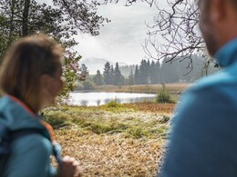
This trail offers constantly changing landscapes as it winds through scenic forests, meadows and numerous viewpoints including the idyllically situated Lake Egelsee, which is why this trail is perfect for a great hiking experience.
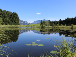
The lake, which covers approximately one hectare is about 7 meter deep, was formed during the last Ice Age and is surrounded by a botanically precious accretion zone. The 6 Insectivorous plants, 12 types of Orchids etc. which can be found there reflect the diversity of the vegetation.
Approx. 2 ½- 3 hours, rather easy hike - 200 m differences in altitude
Starting at the Stockwinkel shipping pier, follow the Attersee State Road uphill to the Egelsee natural reserve. Continue onwards to the "Druckerhof" inn, past the ski lift and then head down the Menerweg, along the sweet chestnut forest back to Unterach. Follow the Klostergasse towards the main square to reach the shipping pier where you started the hike.
This trail offers constantly changing landscapes as it winds through scenic forests, meadows and numerous viewpoints including the idyllically situated Lake Egelsee, which is why this trail is perfect for a great hiking experience.
The lake, which covers approximately one hectare is about 7 meter deep, was formed during the last Ice Age and is surrounded by a botanically precious accretion zone. The 6 Insectivorous plants, 12 types of Orchids etc. which can be found there reflect the diversity of the vegetation.
Approx. 2 ½- 3 hours, rather easy hike - 200 m differences in altitude
Starting point: Maine place in Unterach am Attersee
Destination: Stockwinkel in Unterach am Attersee
further information:
- Experience of nature
- Board possible

Accessibility / arrival
by car:
Coming from Salzburg via the A1 - exit Mondsee
Coming from Vienna/Linz via the A1 - exit St. Georgen, Attersee via Nußdorf to Unterach
Coming from the west - Bad Ischl-Weißenbach-Unterach
by train:
Coming from Salzburg or Linz/Vienna to Vöcklamarkt, then with the Attergau train to Attersee, and by bus to Unterach
by plane:
Coming from Salzburg via the A1 - exit Mondsee
Coming from Vienna/Linz via the A1 - exit St. Georgen
- All weather
- Suitable for groups
- Suitable for schools
- Suitable for teenagers
- Suitable for seniors
- Suitable for single travelers
- Suitable for friends
- Suitable for couples
- Spring
- Summer
- Autumn
Please get in touch for more information.
Hauptstraße 9
4866 Unterach am Attersee
Phone +43 7666 7719 - 50
E-Mail info.unterach@attersee.at
Web attersee-attergau.salzkammergut.at
https://attersee-attergau.salzkammergut.at
You can also visit us on
Visit us on Facebook Visit us on Instagram Visit us on Pinterest Visit our videochannel on YouTube Wikipedia")
")
")
Interactive elevation profile
Create PDF
Tour-Details
Path number: 3
Starting place: 4866 Unterach am Attersee
Destination: 4866 Unterach am Attersee
duration: 2h 13m
length: 6,8 km
Altitude difference (uphill): 262m
Altitude difference (downhill): 275m
Lowest point: 473m
Highest point: 669m
difficulty: medium
condition: medium
panoramic view: Great panorama
Paths covering:
Asphalt, Gravel, Hiking trail
powered by TOURDATA