

From Maierhof to the peak of Hochplett


- All weather
Interactive elevation profile
Create PDF
Tour-Details
Path number: 23
Starting place: 5310 Tiefgraben am Mondsee
Destination: 5310 Tiefgraben am Mondsee
duration: 4h 15m
length: 9,1 km
Altitude difference (uphill): 854m
Altitude difference (downhill): 249m
Lowest point: 494m
Highest point: 1.100m
difficulty: medium
condition: medium
panoramic view: Individual Views
Paths covering:
Asphalt, Hiking trail
powered by TOURDATA
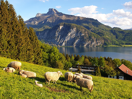
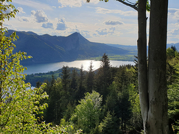
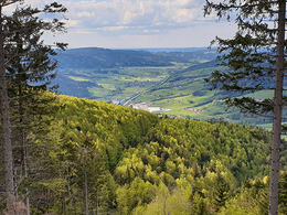
The inconspicuous Hochplettspitz is particularly suitable when the weather is not perfect or as a technically easy hike. Some spectacular views, for example in the village of Bergen and on the way to the summit, reward the effort of the ascent.
We start in the district of Maierhof next to the village of Loibichl walking uphill to the district of Bergen on a tarmac road. On the first peak you are rewarded with a spectacular view over the Mondsee lake. Passing the deer compound you enter the forest on a gravel road. Follow the road slightly increasing until you reach the Hochplettspitze peak with a great view over the Attersee lake. Hike back the same way.
Starting point: Village "Maierhof" in Loibichl at lake Mondsee.
Destination: Peak of Hochplettspitz
")
")
Accessibility / arrival Parking
On the way from Mondsee to Unterach there is a bus stop about one kilometer after the Innerschwand bathing facility on the left before the ascent. This tour starts there.
- Parking space: 3
- All weather
- Suitable for kids (10 - 14 Year)
- Suitable for seniors
- Suitable for single travelers
- Suitable for friends
- Suitable for couples
- Suitable for children
- Spring
- Summer
- Autumn
- Early winter
Please get in touch for more information.
Dr. Franz Müller Straße 3
5310 Innerschwand am Mondsee
Phone +43 6232 2270
E-Mail info@mondsee.at
Web www.mondsee.at
http://www.mondsee.at
Interactive elevation profile
Create PDF
Tour-Details
Path number: 23
Starting place: 5310 Tiefgraben am Mondsee
Destination: 5310 Tiefgraben am Mondsee
duration: 4h 15m
length: 9,1 km
Altitude difference (uphill): 854m
Altitude difference (downhill): 249m
Lowest point: 494m
Highest point: 1.100m
difficulty: medium
condition: medium
panoramic view: Individual Views
Paths covering:
Asphalt, Hiking trail
powered by TOURDATA