

The walk with the hat


- culturally interesting
- Flatly
Interactive elevation profile
Create PDF
Tour-Details
Path number: G
Starting place: 5310 Tiefgraben am Mondsee
Destination: 5310 Tiefgraben am Mondsee
duration: 6h 30m
length: 19,7 km
Altitude difference (uphill): 791m
Altitude difference (downhill): 793m
Lowest point: 510m
Highest point: 953m
difficulty: medium
condition: medium
panoramic view: Individual Views
Paths covering:
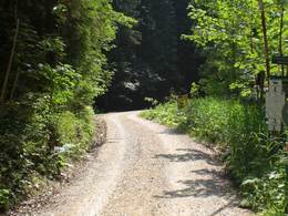
Asphalt, Hiking trail
powered by TOURDATA
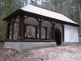
Longer distance walk, signed by a hut A slight incline leads through the woods from the Konradskirche in Oberwang to the Konradsbrunnen with its chapel.
According to legend, this spring has its source at the place where Konrad was murdered. Reports from the Middle Ages also suggest that miracles have happened here. Starting point: Hilfberg, in front of the bridge follow the signs to the right. Höhenweg above the motorway - Innerschwand - Konradsbrunn-Oberwang.
In front of the bridt follow the signs to the right.
Time required 2,5 hours, Reststops: Gasthof Fideler Bauer, Oberwang
")
")
")
")
")

Parking
- Parking space: 100
Most economical season
- Spring
- Summer
- Autumn
- Early winter
Please get in touch for more information.
Dr. Franz Müller Straße 3
5310 Tiefgraben am Mondsee
Phone +43 6232 2270
Fax machine +43 6232 2270 - 22
E-Mail info@mondsee.at
Web www.mondsee.at
http://www.mondsee.at
Interactive elevation profile
Create PDF
Tour-Details
Path number: G
Starting place: 5310 Tiefgraben am Mondsee
Destination: 5310 Tiefgraben am Mondsee
duration: 6h 30m
length: 19,7 km
Altitude difference (uphill): 791m
Altitude difference (downhill): 793m
Lowest point: 510m
Highest point: 953m
difficulty: medium
condition: medium
panoramic view: Individual Views
Paths covering:
Asphalt, Hiking trail
powered by TOURDATA