

THERMENLAUF | Bewegungs-Arena INNVIERTEL


- All weather
Interactive elevation profile
Create PDF
Tour-Details
Starting place: 4943 Geinberg
Destination: 4943 Geinberg
duration: 2h 28m
length: 9,2 km
Altitude difference (uphill): 123m
Altitude difference (downhill): 123m
Lowest point: 375m
Highest point: 463m
difficulty: medium
condition: medium
panoramic view: Individual Views
Paths covering:
Asphalt
powered by TOURDATA
Partial lock: vorübergehende Teilsperre
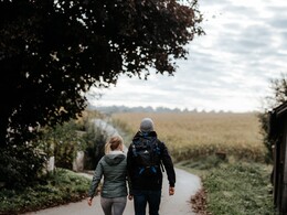
The Thermenlauf round starts at the elementary school and leads from there uphill to the start board of the exercise arena. Continue downhill through Geinberg, to Neuhaus, through Nonsbach to the Danner chapel, where it meets the "Schanke Linie Runde". Contrary to this back to Geinberg. The Thermenlauf Runde is a beautiful, fully paved route that is marked every 1,000 m and is therefore ideal as a training route.
At km 3.6 abbreviation I: Thermenlauf run, short lenght: 5,300 m
At km 6.0 abbreviation II: Thermenlauf run, medium length: 8,800 m
At km 3.6 abbreviation I: Thermenlauf run, short lenght: 5,300 m
At km 6.0 abbreviation II: Thermenlauf run, medium length: 8,800 m
- All weather
- Suitable for groups
- Suitable for single travelers
- Suitable for friends
- Suitable for couples
- Spring
- Summer
- Autumn
- Early winter
- Deep winter
Please get in touch for more information.
4943 Geinberg
Phone +43 7723 8555
Fax machine +43 7723 8555 - 4
E-Mail info@innviertel-tourismus.at
Web www.innviertel-tourismus.at
https://www.innviertel-tourismus.at
Interactive elevation profile
Create PDF
Tour-Details
Starting place: 4943 Geinberg
Destination: 4943 Geinberg
duration: 2h 28m
length: 9,2 km
Altitude difference (uphill): 123m
Altitude difference (downhill): 123m
Lowest point: 375m
Highest point: 463m
difficulty: medium
condition: medium
panoramic view: Individual Views
Paths covering:
Asphalt
powered by TOURDATA