

SCHLANKE LINIE RUNDE (Panorama-Runde) |- Bewegungs-Arena


- All weather
- Suitable for families
Interactive elevation profile
Create PDF
Tour-Details
Starting place: 4943 Geinberg
Destination: 4943 Geinberg
duration: 1h 41m
length: 6,4 km
Altitude difference (uphill): 72m
Altitude difference (downhill): 73m
Lowest point: 402m
Highest point: 474m
difficulty: medium
condition: medium
panoramic view: Some Views
Paths covering:
Asphalt, Hiking trail
powered by TOURDATA
Partial lock: vorübergehende Teilsperre
Starting point: Red Cross
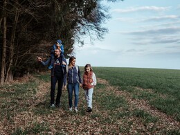
The Schlanke Linie loop starts together with route 2 and 5 and leads contrary to the thermal run to the Danner Chapel. Continue to Ellreching, through the Geinberg forest and back to the starting point. This only slightly undulating route with changing terrain offers fantastic views and can be extended in conjunction with the Innviertel Round or the Lagerhaus Round depending on your fitness.
The Schlanke Linie loop starts together with route 2 and 5 and leads contrary to the thermal run to the Danner Chapel. Continue to Ellreching, through the Geinberg forest and back to the starting point. This only slightly undulating route with changing terrain offers fantastic views and can be extended in conjunction with the Innviertel Round or the Lagerhaus Round depending on your fitness.
- All weather
- Suitable for seniors
- Suitable for single travelers
- Suitable for friends
- Spring
- Summer
- Autumn
- Early winter
- Deep winter
Please get in touch for more information.
4943 Geinberg
Phone +43 7723 8555
Fax machine +43 7723 8555 - 4
E-Mail info@innviertel-tourismus.at
Web www.innviertel-tourismus.at
http://www.innviertel-tourismus.at
Interactive elevation profile
Create PDF
Tour-Details
Starting place: 4943 Geinberg
Destination: 4943 Geinberg
duration: 1h 41m
length: 6,4 km
Altitude difference (uphill): 72m
Altitude difference (downhill): 73m
Lowest point: 402m
Highest point: 474m
difficulty: medium
condition: medium
panoramic view: Some Views
Paths covering:
Asphalt, Hiking trail
powered by TOURDATA