

My way up the Magdalena Mountain


- pets allowed
- All weather
- Suitable for families
- culturally interesting
Interactive elevation profile
Create PDF
Tour-Details
Starting place: 4701 Bad Schallerbach
Destination: 4701 Bad Schallerbach
duration: 0h 15m
length: 0,5 km
Altitude difference (uphill): 58m
Lowest point: 329m
Highest point: 393m
difficulty: medium
condition: medium
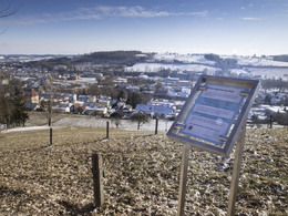
panoramic view: Some Views
Paths covering:
Gravel, Other
powered by TOURDATA
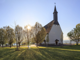
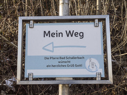
The Magdalena Church is a popular destination all year round. Locals like to stroll up the Magdalenaberg as much as guests. Along the footpath, five panels of the parish of Bad Schallerbach invite you to consciously set out on your way. "My path" gives impulses to pause and reflect. The boards provide information about the three churches in Bad Schallerbach and invite families to solve exciting riddles together with their children. The children's puzzles can be downloaded to a smartphone using a QR code. Likewise, one receives detailed information about the churches via QR code.
Starting point: Left of Gästehaus Pfisterer, Magdalenabergstraße 5, 4701 Bad Schallerbach
Destination: Magdalenaberg Church, 4701 Bad Schallerbach
further information:
Details - hiking
- themed path
")


Accessibility / arrival
You can find parking spaces in the village
- All weather
- Suitable for groups
- Suitable for schools
- Pets allowed
- Suitable for teenagers
- Suitable for seniors
- Suitable for single travelers
- Suitable for friends
- Suitable for couples
- Suitable for children
- Spring
- Summer
- Autumn
- Early winter
Not suitable for wheelchairs. The property is not compliant with Austria's ÖNORM legal standard.
Promenade 2
4701 Bad Schallerbach
Phone +43 7249 42071 - 0
E-Mail info@vitalwelt.at
Web www.vitalwelt.at
https://www.vitalwelt.at
Interactive elevation profile
Create PDF
Tour-Details
Starting place: 4701 Bad Schallerbach
Destination: 4701 Bad Schallerbach
duration: 0h 15m
length: 0,5 km
Altitude difference (uphill): 58m
Lowest point: 329m
Highest point: 393m
difficulty: medium
condition: medium
panoramic view: Some Views
Paths covering:
Gravel, Other
powered by TOURDATA