

Brunnkogel im Höllengebirge


Interactive elevation profile
Create PDF
Tour-Details
Path number: 828
Starting place: 4802 Ebensee
Destination: 4802 Ebensee
duration: 7h 20m
length: 13,2 km
Altitude difference (uphill): 1.256m
Altitude difference (downhill): 1.269m
Lowest point: 667m
Highest point: 1.658m
difficulty: difficult
condition: difficult
panoramic view: Great panorama
Paths covering:
Gravel, Hiking trail
powered by TOURDATA
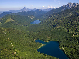
The impressive 14 metre high summit cross and an impressive view down into the valley to the Vorderer and Hinterer Langbathsee lakes make the Brunnkogel a popular hiking destination for sure-footed hikers with a head for heights.
It's unbelievable what remote areas were once used as alpine pastures: An exposed cattle track has even been built up to the Schafalm below the Brunnkogel - the serpentines were carved directly out of the 400 metre high rock base of the "Schaflucken". From the former sports hotel, we walk either to the right or left of the Vorderer Langbathsee lake to the Hinterer Langbathsee lake. The Schafluckensteig trail, marked no. 828, branches off on its southern shore. It leads through rough forest terrain up to the foot of the wall. The belays begin above a wooden gate: A secured scree ramp leads to an artificially widened ledge, then steep switchbacks and another ledge take you up to the eastern precipices of the Spielberg. Through a wooded hollow and a gully filled with scree, you reach the upper, somewhat less exposed wall step (belays). Above this you walk through the forest and past the ruined Schafalm (hunting lodge). At a cairn, branch off to the right and climb through the wide meadow flank to the ridge and briefly to the 14 m high summit cross on the Brunnkogel. Return along the same route.
It's unbelievable what remote areas were once used as alpine pastures: An exposed cattle track has even been built up to the Schafalm below the Brunnkogel - the serpentines were carved directly out of the 400 metre high rock base of the "Schaflucken". From the former sports hotel, we walk either to the right or left of the Vorderer Langbathsee lake to the Hinterer Langbathsee lake. The Schafluckensteig trail, marked no. 828, branches off on its southern shore. It leads through rough forest terrain up to the foot of the wall. The belays begin above a wooden gate: A secured scree ramp leads to an artificially widened ledge, then steep switchbacks and another ledge take you up to the eastern precipices of the Spielberg. Through a wooded hollow and a gully filled with scree, you reach the upper, somewhat less exposed wall step (belays). Above this you walk through the forest and past the ruined Schafalm (hunting lodge). At a cairn, branch off to the right and climb through the wide meadow flank to the ridge and briefly to the 14 m high summit cross on the Brunnkogel. Return along the same route.
Most economical season
- Spring
- Summer
- Autumn
Please get in touch for more information.
oberhalb des Hinteren Langbathsees
4802 Ebensee
Phone +43 6133 8016
E-Mail ebensee@traunsee-almtal.at
Web www.traunsee-almtal.at/ebensee
http://www.traunsee-almtal.at/ebensee
")
Interactive elevation profile
Create PDF
Tour-Details
Path number: 828
Starting place: 4802 Ebensee
Destination: 4802 Ebensee
duration: 7h 20m
length: 13,2 km
Altitude difference (uphill): 1.256m
Altitude difference (downhill): 1.269m
Lowest point: 667m
Highest point: 1.658m
difficulty: difficult
condition: difficult
panoramic view: Great panorama
Paths covering:
Gravel, Hiking trail
powered by TOURDATA