© Photo: Oberösterreich Tourismus GmbH./Robert Maybach: Enjoy the view in Upper Austria


Ebenforstalm - Round tour


- Flatly
Interactive elevation profile
Create PDF
Tour-Details
Starting place: 4462 Reichraming
Destination: 4462 Reichraming
duration: 6h 3m
length: 44,5 km
Altitude difference (uphill): 1.239m
Altitude difference (downhill): 1.239m
Lowest point: 380m
Highest point: 1.164m
difficulty: difficult
condition: very difficult
panoramic view: Individual Views
Paths covering:
Asphalt, Path / trail, Gravel, Hiking trail, Other
powered by TOURDATA
Short description:
Parkplatz Weißenbach -Geisshanslniedern - Hausbach - links Boddinggraben - Messerer Häusl links - Ebenforstalm - Widen Graben - Parkplatz Weißenbach
Parkplatz Weißenbach -Geisshanslniedern - Hausbach - links Boddinggraben - Messerer Häusl links - Ebenforstalm - Widen Graben - Parkplatz Weißenbach
Recommended season:
- April
- May
- June
- July
- August
- September
- October
Properties:
Description:- Loop
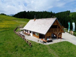
The tour starts at the parking lot Weißenbach and leads as the first climb up to the Geisshanslniedern. Then it goes downhill into the Hausbach. At the bottom, turn left in the direction of Bodinggraben. At the Messerer Häusl turn left towards Ebenforstalm. The second mountain climb begins and leads up to the Ebenforstalm. After a leisurely stop for refreshments, the trail only continues downhill through the Hintergebirge mountains via the Wilden Graben and finally along the Großer Bach stream back to the starting point.
Translated with www.DeepL.com/Translator (free version)
Directions:The tour starts at the parking lot Weißenbach and leads as the first climb up to the Geisshanslniedern. Then it goes downhill into the Hausbach. At the bottom, turn left in the direction of Bodinggraben. At the Messerer Häusl turn left towards Ebenforstalm. The second mountain climb begins and leads up to the Ebenforstalm. After a leisurely stop for refreshments, the trail only continues downhill through the Hintergebirge mountains via the Wilden Graben and finally along the Großer Bach stream back to the starting point.
Translated with www.DeepL.com/Translator (free version)
Safety guidelines:Find out in advance about any road closures along the bike route and www.steyr-nationalpark.at.Equipment:
Sun and rain protection, repair kit for minor bike breakdowns.Additional information:
You can obtain map material at www.steyr-nationalpark.at
Starting point: Parkplatz Weißenbach
Destination: Parkplatz Weißenbach
further information:
- Flatly
details mountainbike
- Riding technique: difficult

Buchensteig Station 1: Mesophiler Buchenwald

Buchensteig Station 2: Die Buche – Mutter des Waldes

Buchensteig Station 3: Vom Fichtenforst zum Mischwald

Buchensteig Station 4: Trockenhang-Buchenwald

Buchensteig Station 5: Natürliche Wälder – ganz schön lebendig

Buchensteig Station 6: Vogelparadies Wilder Graben

Buchensteig Station 7: Windwurf

Naturschutzgebiet Jaidhaus, Buckelwiesen

Reiterhof Rohrauer

Weißenbachkapelle
Parking fees
none
- Suitable for single travelers
- Suitable for friends
- Suitable for couples
- Spring
- Summer
- Autumn
Please get in touch for more information.
Stadtplatz 27
4400 Steyr
Phone +43 7252 53229 - 0
E-Mail reichraming@steyr-nationalpark.at
Web www.steyr-nationalpark.at/
https://www.steyr-nationalpark.at/
Interactive elevation profile
Create PDF
Tour-Details
Starting place: 4462 Reichraming
Destination: 4462 Reichraming
duration: 6h 3m
length: 44,5 km
Altitude difference (uphill): 1.239m
Altitude difference (downhill): 1.239m
Lowest point: 380m
Highest point: 1.164m
difficulty: difficult
condition: very difficult
panoramic view: Individual Views
Paths covering:
Asphalt, Path / trail, Gravel, Hiking trail, Other
powered by TOURDATA