

Priel via ferrata (C/D)


- Suitable for families
Interactive elevation profile
Create PDF
Tour-Details
Starting place: 4573 Hinterstoder
Destination: 4573 Hinterstoder
duration: 13h 10m
length: 17,9 km
Altitude difference (uphill): 2.411m
Altitude difference (downhill): 2.406m
Lowest point: 611m
Highest point: 2.431m
difficulty: difficult
condition: difficult
panoramic view: Great panorama
Paths covering:
Climbing mount, Gravel, Hiking trail
powered by TOURDATA
The longest via ferrata in Austria
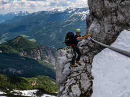
With a length of 2,130 metres (!) and 900 metres in altitude, the Priel via ferrata is one of the longest and most demanding in the Eastern Alps. It is the longest in Austria. The steel cable leads directly to the mighty red summit cross of the Großer Priel (2,515 m), the highest peak in the Tote Gebirge.
In 2017/2018, the existing via ferratas Bert-Rinesch and Sporn were merged, generally renovated and extended downwards.
How difficult will it be?
The longest via ferrata in Austria requires experience, endurance and stamina. It is well secured throughout.
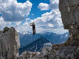
Rope bridges, caves, overhangs, ...
The climb starts with several D-points: two cave passages, two rope bridges, exposed traverses, straddle steps, riding ridge and overhangs make the new section a special experience. At the Sporngipfel you can descend to the left (south) and divide the climb into two days. Should you not be able to cope with the so-called locomotive of the tour, you can use the last emergency exit directly after the second rope bridge. Here you have completed the first third and the old Bert Rinesch via ferrata section begins.
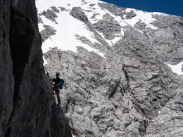
via ferrata section begins. New ropes and better placed anchors have made this section somewhat easier and more pleasant than before the renovation. The "old" via ferrata runs through partly overhanging passages on ladders (C-D) and longer, sometimes very exposed traverses. The length of the path, combined with the vertical steep climbs with ladders and brackets, demand a lot from your physical condition. Only in the upper part does the terrain flatten out and you follow the south ridge to the summit.
Can it be easier?
If you bypass the Affenschädl and the first cave on the signposted alternative routes on the left, you will manage with difficulty C. From the Sporn summit cross you can descend on the steel rope to the first rope bridge and again manage with difficulty C up to the second rope bridge. From here you either descend southwards to the refuge or follow the wire section on the long, well-known Bert Rinesch section with difficulty level C/D.
Can I abort?
If you notice that you are not up to the longest via ferrata in Austria, you have 2 options for an emergency exit:
1. from the Sporngipfel on the south side, or
2. after the second rope bridge (locomotive)
With a length of 2,130 metres (!) and 900 metres in altitude, the Priel via ferrata is one of the longest and most demanding in the Eastern Alps. It is the longest in Austria. The steel cable leads directly to the mighty red summit cross of the Großer Priel (2,515 m), the highest peak in the Tote Gebirge.
In 2017/2018, the existing via ferratas Bert-Rinesch and Sporn were merged, generally renovated and extended downwards.
How difficult will it be?
The longest via ferrata in Austria requires experience, endurance and stamina. It is well secured throughout.
Rope bridges, caves, overhangs, ...
The climb starts with several D-points: two cave passages, two rope bridges, exposed traverses, straddle steps, riding ridge and overhangs make the new section a special experience. At the Sporngipfel you can descend to the left (south) and divide the climb into two days. Should you not be able to cope with the so-called locomotive of the tour, you can use the last emergency exit directly after the second rope bridge. Here you have completed the first third and the old Bert Rinesch via ferrata section begins.
via ferrata section begins. New ropes and better placed anchors have made this section somewhat easier and more pleasant than before the renovation. The "old" via ferrata runs through partly overhanging passages on ladders (C-D) and longer, sometimes very exposed traverses. The length of the path, combined with the vertical steep climbs with ladders and brackets, demand a lot from your physical condition. Only in the upper part does the terrain flatten out and you follow the south ridge to the summit.
Can it be easier?
If you bypass the Affenschädl and the first cave on the signposted alternative routes on the left, you will manage with difficulty C. From the Sporn summit cross you can descend on the steel rope to the first rope bridge and again manage with difficulty C up to the second rope bridge. From here you either descend southwards to the refuge or follow the wire section on the long, well-known Bert Rinesch section with difficulty level C/D.
Can I abort?
If you notice that you are not up to the longest via ferrata in Austria, you have 2 options for an emergency exit:
1. from the Sporngipfel on the south side, or
2. after the second rope bridge (locomotive)
Starting point: Paid parking lot Polsterlucke
Destination: Paid parking lot Polsterlucke
Details - climbing mount
- difficulty acc. to Kurt Schall: very difficult (D)
- Hop off description: (35 min | 220 hm) 150 metres just above the Prielschutzhaus, the approach to the via ferrata branches off to the right. The marked trail leads through mountain pines and meadows to the entrance on the southeast spur.
- Hop on description: (2 h | 1,100 hm) From the summit, follow the normal route over the west ridge to the Brotfallscharte and then over a secured path down to the snow field and back to the Prielschutzhaus (2 h).
- duration climbing mount: 6 h
- duration Descent: 2 h
July to September, when there is no snow. Due to its east-facing orientation, the Priel via ferrata is very critical with regard to weather changes, as the massive mountain obscures your view of the approaching fronts. So be sure to check the weather forecast!
")
Accessibility / arrival
Ascent to the Prielschutzhaus from Hinterstoder, Polsterlucke car park (2.5 hours). Due to its length, we recommend spending the night at the Prielschuthaus before tackling the Priel via ferrata (T +43 7564 206 02).
Travel sustainably?
Ride your bike from Hinterstoder town centre (or Hinterstoder train station) to the Polsterstüberl, where you can charge your e-bike. You can find details in our Bike&Hike-Tour.
- Suitable for friends
- Suitable for couples
- Summer
- Autumn
Please get in touch for more information.
Nr. 38
4573 Hinterstoder
Phone +43 7564 5263
Fax machine +43 7564 5263 - 30
E-Mail hinterstoder@pyhrn-priel.net
Web www.urlaubsregion-pyhrn-priel.at/
https://www.urlaubsregion-pyhrn-priel.at/
You can also visit us on
Visit us on Facebook Visit us on Instagram Visit us on Pinterest Visit our videochannel on YouTubeInteractive elevation profile
Create PDF
Tour-Details
Starting place: 4573 Hinterstoder
Destination: 4573 Hinterstoder
duration: 13h 10m
length: 17,9 km
Altitude difference (uphill): 2.411m
Altitude difference (downhill): 2.406m
Lowest point: 611m
Highest point: 2.431m
difficulty: difficult
condition: difficult
panoramic view: Great panorama
Paths covering:
Climbing mount, Gravel, Hiking trail
powered by TOURDATA