

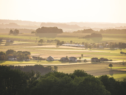
7 Tour "Genussroas-Runde"


- Flatly
- Possible accommodation
Interactive elevation profile
Create PDF
Tour-Details
Starting place: 4880 Berg im Attergau
Destination: 4880 Berg im Attergau
duration: 2h 0m
length: 6,5 km
Altitude difference (uphill): 50m
difficulty: easy
condition: easy
panoramic view: Some Views
Paths covering:
Asphalt
powered by TOURDATA
Genussroas round in Berg im Attergau - on this walk 6 businesses from agriculture, catering and trade present themselves.
You start at the restaurant Voralpenhotel Schmoller in Hipping and walk in the direction of Biobauernhof Schernthaner, then turn right in the direction of Kogl. You stay on the right side
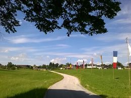
and after the forest you reach the Landgasthof Spitzer. One Thanham (here you have the possibility to shorten the walk) and you reach and comes to Pössing to the Genussbackstube Muss. If you want, you can take the path 1d Hipping-Hag back to Hipping. back to Hipping. Or you can follow the road through Pössing to get to the small the small village of Raith. You pass the Rabanser farm. As soon as you enter the forest take the narrow forest path on the right, which leads to the edge of the forest. edge of the forest. At the first fork keep left and at the second fork follow the road to the right. At the second fork you follow the road to the right, then straight on back to Hipping. If you want to extend the route a bit more, you can go to Walsberg. You turn at "Drahtwaren Enzi" and then you go to the railroad station Walsberg. Along the tracks you come back to Hipping.
Special feature: On this walk 6 businesses from agriculture,
gastronomy and trade.
You start at the restaurant Voralpenhotel Schmoller in Hipping and walk in the direction of Biobauernhof Schernthaner, then turn right in the direction of Kogl. You stay on the right side
and after the forest you reach the Landgasthof Spitzer. One Thanham (here you have the possibility to shorten the walk) and you reach and comes to Pössing to the Genussbackstube Muss. If you want, you can take the path 1d Hipping-Hag back to Hipping. back to Hipping. Or you can follow the road through Pössing to get to the small the small village of Raith. You pass the Rabanser farm. As soon as you enter the forest take the narrow forest path on the right, which leads to the edge of the forest. edge of the forest. At the first fork keep left and at the second fork follow the road to the right. At the second fork you follow the road to the right, then straight on back to Hipping. If you want to extend the route a bit more, you can go to Walsberg. You turn at "Drahtwaren Enzi" and then you go to the railroad station Walsberg. Along the tracks you come back to Hipping.
Special feature: On this walk 6 businesses from agriculture,
gastronomy and trade.
Starting point: Hipping parking lot Schmoller Inn
Destination: Hipping parking lot Schmoller Inn
further information:
- Flatly
- Possible accommodation
- Board possible
Accessibility / arrival
Car:
From Salzburg via the A1 - exit St. Georgen im Attergau - continue right on the
Attergaustrasse L540 in the direction of the city center
From Vienna/Linz via the A1 - exit St. Georgen im Attergau - continue right on the
Attergaustrasse L540 direction center
From the west - Bad Ischl - Weißenbachtal (B153) - further on B152 to Unterach - then
on B151 to Attersee- further on L540 to St. Georgen im Attergau
By train:
Coming from Salzburg or Linz/Vienna with the "Österreichische Bundesbahnen" or the
"Westbahn" to Attnang-Puchheim, continue with the regional train to Vöcklamarkt
to St. Georgen im Attergau
Plane:
Arrival in Salzburg or Linz/Vienna, continue by car/bus or train.
Most economical season
- Spring
- Summer
- Autumn
Please get in touch for more information.

Attergaustraße 55
4880 St. Georgen im Attergau
Phone +43 7666 7719 - 80
E-Mail info.attergau@attersee.at
Web attersee-attergau.salzkammergut.at
http://attersee-attergau.salzkammergut.at
You can also visit us on
Visit us on Facebook Visit us on Instagram Visit us on Pinterest Visit our videochannel on YouTube Wikipedia")
")
")
Interactive elevation profile
Create PDF
Tour-Details
Starting place: 4880 Berg im Attergau
Destination: 4880 Berg im Attergau
duration: 2h 0m
length: 6,5 km
Altitude difference (uphill): 50m
difficulty: easy
condition: easy
panoramic view: Some Views
Paths covering:
Asphalt
powered by TOURDATA