

Ried circular route


- Flatly
Interactive elevation profile
Create PDF
Tour-Details
Path number: 1
Starting place: 5360 St. Wolfgang im Salzkammergut
Destination: 5360 St. Wolfgang im Salzkammergut
duration: 1h 36m
length: 5,9 km
Altitude difference (uphill): 80m
Altitude difference (downhill): 79m
Lowest point: 538m
Highest point: 578m
difficulty: easy
condition: easy
panoramic view: Some Views
Paths covering:
Asphalt, Gravel
powered by TOURDATA
An easy circular run on tarmac (street lighting).
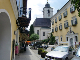
Start at the Kurdirektion (tourist office) in St. Wolfgang, along Michael Pacher Straße (road) to Markplatz (market square), along the lakeside via the Untere Rieder Straße (road) to Ried. 100m after the Gasthaus Falkenstein (restaurant), turn right onto the Obere Rieder Straße (road) and return to the starting point.
Distance: 6 km
Elevation difference: 40 m
Gravel-Course: 0 km
Tarmac-Course: 6 km
Time: 19 to 36 min
Nordic Walking: 60 min
Starting point: Tourist Info St. Wolfgang
Destination: Tourist Info St. Wolfgang
further information:
- Flatly
Accessibility / arrival
On the country road to St. Wolfgang
Parking- Parking space: 2
- Suitable for kids (10 - 14 Year)
- Suitable for single travelers
- Suitable for friends
- Suitable for couples
- Spring
- Summer
- Autumn
Please get in touch for more information.
Au 140
5360 St. Wolfgang im Salzkammergut
Phone +43 6138 8003
E-Mail info@wolfgangsee.at
Web wolfgangsee.salzkammergut.at/
https://wolfgangsee.salzkammergut.at/
Interactive elevation profile
Create PDF
Tour-Details
Path number: 1
Starting place: 5360 St. Wolfgang im Salzkammergut
Destination: 5360 St. Wolfgang im Salzkammergut
duration: 1h 36m
length: 5,9 km
Altitude difference (uphill): 80m
Altitude difference (downhill): 79m
Lowest point: 538m
Highest point: 578m
difficulty: easy
condition: easy
panoramic view: Some Views
Paths covering:
Asphalt, Gravel
powered by TOURDATA