

Leadership fixed rope route


Interactive elevation profile
Create PDF
Tour-Details
Paths covering:
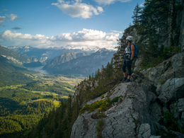
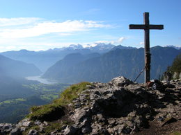
Interesting via ferrata on the Predigstuhl of Bad Goisern at Lake Hallstatt.
Wonderful via ferrata to the "Predigtstuhl"
Especially in the upper part of the via ferrata offers original climbing points such as a luff and the ridge. To extend the tour a bit, it is advisable to attach to the Predigstuhl via ferrata still the Törlwand fixed rope route and possibly the Ewige Wand fixed rope route.
Detailed route description:
In the steep entry wall (C) equal arm force is demanded. About three sloping ladders (A / B), it goes to the left to a small overhang (C) which leads into a rock gap with terminal block (the ropes on the right belonging to a high-rise system are ignored.). This steeply up (C) and and to a dizzying exposed ridge (B / C). Then over the last fuses to the summit.
In case of emergency call the mountain rescue under 140!
Download the via ferrata guide of Bad Goisern at Lake Hallstatt, Gosau at Dachstein, Hallstatt and Obertraun.
Details - climbing mount
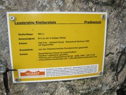
- difficulty acc. to Kurt Schall: difficult (C)
- Hop off description: Starting at the parking lot Predigtstuhl in the northeast direction, following the marked forest trail until you reach the junction turning left on the trail to the Predigtstuhl. Follow this trail for about 15 minutes till you find the trail to the via ferrata (sign: "Klettersteig").
- Hop on description: Decent via the marked normal trail.
- duration hop on: 1 h
The via ferrata is accessible from May to October, depending on snow and weather conditions.
In Bad Goisern take the exit for Lasern at the roundabout and continue along the scenic road in the direction of Predigstuhl until you reach the free parking lot Predigstuhl.
by car
from Salzburg:
Exit Thalgau via federal road B158 towards Bad Ischl, in Bad Ischl drive onto Salzkammergut Street B145 towards Bad Goisern
from Linz:
Exit Regau via federal road Salzkammergut street B145 towards Gmunden and Bad Ischl to Bad Goisern
from Vienna/Graz:
Exit Liezen via federal road B320, in Trautenfels drive onto Salzkammergut street B145 towards Bad Goisern
from Villach:
Tauern motorway to exit "Eben im Pongau", via B166 Pass Gschütt federal road through Gosau, at the Gosaumühle junction turn towards Bad Goisern
by train
Attnang-Puchheim - Stainach-Irdning lines
stop train station Bad Goisern, from there about 6.6 km away
by bus
Bus 542 (Bad Ischl - Gosausee)
stop Bad Goisern Mitte/B145, from there about 5.8 km away
Detailed information on the respective train and bus times can be found at https://www.oebb.at/en/ (train) and https://www.postbus.at/en (bus).
- Parking space: 100
- Bus parking space: 2
for free
All via ferrata are free to use at your own risk.
- Suitable for single travelers
- Suitable for friends
- Suitable for couples
Not suitable for children!
Complete climbing equipment is required!
- Summer
- Autumn
Please get in touch for more information.
")
Steinach 4
4822 Bad Goisern am Hallstättersee
Phone +43 6135 6058
E-Mail office@outdoor-leadership.com
Web www.dachstein-salzkammergut.at
Web www.outdoor-leadership.com
http://www.outdoor-leadership.com
You can also visit us on
Visit us on Facebook Visit us on Instagram Visit us on Pinterest Visit our videochannel on YouTube WikipediaInteractive elevation profile
Create PDF
Tour-Details
Paths covering: