

Eggerbauer route - running & walking park - orange S5


- Possible accommodation
Interactive elevation profile
Create PDF
Tour-Details
Starting place: 4582 Spital am Pyhrn
Destination: 4582 Spital am Pyhrn
duration: 1h 13m
length: 4,3 km
Altitude difference (uphill): 72m
Altitude difference (downhill): 125m
Lowest point: 640m
Highest point: 757m
difficulty: medium
condition: medium
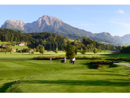
panoramic view: Individual Views
Paths covering:
Asphalt, Gravel
powered by TOURDATA
Runnersfun running & walking park in Spital am Pyhrn - Eggerbauer Runde & Windischgarsten connecting route - orange
This tour begins on the Wur course, leaving it to the left at km 2.9 and presenting you with a challenging climb.
Starting at km 1.3, the path leads downhill, and at km 3.5 you will meet up with the route of the Windischgarsten running and walking park. A flat path will then take you back to Gasthof Kaspar.
The return route to Spital am Pyhrn can also be made via the R31 cycle path (orange line).
Starting point: Spital am Pyhrn route 4 kilometer 2,9
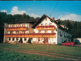
Destination: Gasthof Kaspar
further information:
- Possible accommodation
- Board possible
")
Accessibility / arrival
connection route
Most economical season
- Spring
- Summer
- Autumn
Please get in touch for more information.

Stiftsplatz 1
4582 Spital am Pyhrn
Phone +43 7563 249
Fax machine +43 7563 249 - 20
E-Mail spital@pyhrn-priel.net
Web www.urlaubsregion-pyhrn-priel.at
http://www.urlaubsregion-pyhrn-priel.at
")
")
Interactive elevation profile
Create PDF
Tour-Details
Starting place: 4582 Spital am Pyhrn
Destination: 4582 Spital am Pyhrn
duration: 1h 13m
length: 4,3 km
Altitude difference (uphill): 72m
Altitude difference (downhill): 125m
Lowest point: 640m
Highest point: 757m
difficulty: medium
condition: medium
panoramic view: Individual Views
Paths covering:
Asphalt, Gravel
powered by TOURDATA