

Pfarrersattelweg


- Suitable for families
- Suitable for kids (all ages)
- culturally interesting
Interactive elevation profile
Create PDF
Tour-Details
Path number: 4
Starting place: 4853 Steinbach am Attersee
Destination: 4853 Steinbach am Attersee
duration: 0h 45m
length: 2,0 km
Altitude difference (uphill): 80m
Altitude difference (downhill): 49m
Lowest point: 485m
Highest point: 565m
difficulty: very easy
condition: very easy
panoramic view: Great panorama
Paths covering:
Path / trail, unfixed, Hiking trail
powered by TOURDATA
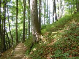
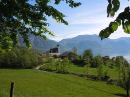
The Pfarrersattelweg, hiking trail number 4, is a short high-altitude trail through the forest with wonderful views of the lake and the surrounding landscape. Starting from Kiental we cross the Feichtweg after a short time. We now keep left and walk along the beautiful, easy to walk Pfarrersattelweg through woods and grassland . We enjoy the magnificent view onto the lake and the church.
Parking
- Parking space: 5
- Free entry
- Suitable for kids (all ages)
- Suitable for teenagers
- Suitable for seniors
- Suitable for single travelers
- Suitable for friends
- Suitable for couples
- Suitable for children
- Spring
- Summer
- Early winter
Please get in touch for more information.
Steinbach 5
4853 Steinbach am Attersee
Phone +43 7666 7719 - 60
E-Mail info.steinbach@attersee.at
Web attersee-attergau.salzkammergut.at
https://attersee-attergau.salzkammergut.at
You can also visit us on
Visit us on Facebook Visit our videochannel on YouTube WikipediaInteractive elevation profile
Create PDF
Tour-Details
Path number: 4
Starting place: 4853 Steinbach am Attersee
Destination: 4853 Steinbach am Attersee
duration: 0h 45m
length: 2,0 km
Altitude difference (uphill): 80m
Altitude difference (downhill): 49m
Lowest point: 485m
Highest point: 565m
difficulty: very easy
condition: very easy
panoramic view: Great panorama
Paths covering:
Path / trail, unfixed, Hiking trail
powered by TOURDATA