

24a eco-trail
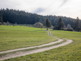


- culinary interesting
- Flatly
Interactive elevation profile
Create PDF
Tour-Details
Path number: 24a
Starting place: 4191 Vorderweißenbach
Destination: 4191 Vorderweißenbach
duration: 1h 48m
length: 5,7 km
Altitude difference (uphill): 197m
Altitude difference (downhill): 192m
Lowest point: 708m
Highest point: 910m
difficulty: medium
condition: medium
panoramic view: Some Views
Paths covering:
Asphalt, Gravel, Hiking trail
powered by TOURDATA
General price information
free
Most economical season
- Spring
- Summer
- Autumn
Please get in touch for more information.
Hauptplatz 19
4190 Bad Leonfelden
Phone +43 7213 6397
E-Mail office@muehlviertlerhochland.at
Web www.muehlviertlerhochland.at
https://www.muehlviertlerhochland.at
")
")

")
Interactive elevation profile
Create PDF
Tour-Details
Path number: 24a
Starting place: 4191 Vorderweißenbach
Destination: 4191 Vorderweißenbach
duration: 1h 48m
length: 5,7 km
Altitude difference (uphill): 197m
Altitude difference (downhill): 192m
Lowest point: 708m
Highest point: 910m
difficulty: medium
condition: medium
panoramic view: Some Views
Paths covering:
Asphalt, Gravel, Hiking trail
powered by TOURDATA