

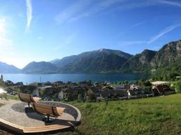
Time Travel Trail in Unterach am Attersee


- pets allowed
- All weather
- Suitable for families
- Suitable for kids (all ages)
- Flatly
Interactive elevation profile
Create PDF
Tour-Details
Starting place: 4866 Unterach am Attersee
Destination: 4866 Unterach am Attersee
duration: 1h 0m
length: 1,9 km
Altitude difference (uphill): 52m
Altitude difference (downhill): 48m
Lowest point: 471m
Highest point: 518m
difficulty: easy
condition: easy
panoramic view: Some Views
Paths covering:
Asphalt, Gravel, Hiking trail, Other
powered by TOURDATA
Welcome on "Zeitreiseweg" Unterach am Attersee Places change their appearance mostly slowly, but steadily. Those who wander through their home town every day often no longer notice these changes.
We say, "Time leaves its mark". Not only in the faces of people, but also in our landscape and architecture. Where a monument was once built is now a park. Where milk cans were available for the horse-drawn carts, commuters are waiting for the bus today.
Every generation has new requirements for "their" home. Much of what shaped spaces and landscapes over time has been used, remodeled or removed.
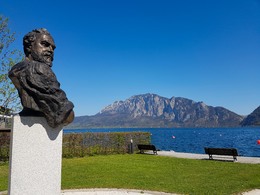
However, if we take a closer look, we may be able to trace the places of the past. And to develop a feeling for the life of the "noble society", which was then attracted to Unterach.
It is always exciting. When you keep your eyes and ears open, it usually does not take long to find what you're looking for and the older generation begins to tell, "Can you remember what it was like back then ..."
However, we humans are transient, so often interesting information about your own place is lost.
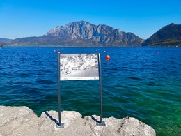
Therefore, we from the tourist association Unterach have gone to search for clues, rummaged in old archives and found literature, postcards and ancient knowledge. We asked what the streets, houses or squares we knew before looked like. Who were the people who lived in it and how these spaces and places were used?
Here we present the result of our work. And we cordially invite you to join us on the "journey through time" through Unterach. Check out our file with all of the pictures and descriptions.
We say, "Time leaves its mark". Not only in the faces of people, but also in our landscape and architecture. Where a monument was once built is now a park. Where milk cans were available for the horse-drawn carts, commuters are waiting for the bus today.
Every generation has new requirements for "their" home. Much of what shaped spaces and landscapes over time has been used, remodeled or removed.
However, if we take a closer look, we may be able to trace the places of the past. And to develop a feeling for the life of the "noble society", which was then attracted to Unterach.
It is always exciting. When you keep your eyes and ears open, it usually does not take long to find what you're looking for and the older generation begins to tell, "Can you remember what it was like back then ..."
However, we humans are transient, so often interesting information about your own place is lost.
Therefore, we from the tourist association Unterach have gone to search for clues, rummaged in old archives and found literature, postcards and ancient knowledge. We asked what the streets, houses or squares we knew before looked like. Who were the people who lived in it and how these spaces and places were used?
Here we present the result of our work. And we cordially invite you to join us on the "journey through time" through Unterach. Check out our file with all of the pictures and descriptions.
Starting point: Ship landing stage Unterach am Attersee
Destination: Gustav Klimt Place Unterach am Attersee
further information:
- Flatly
- Board possible
Details - hiking
- themed path
Accessibility / arrival
by car:
Coming from Salzburg via the A1 - exit Mondsee
Coming from Vienna/Linz via the A1 - exit St. Georgen, Attersee via Nußdorf to Unterach
Coming from the west - Bad Ischl-Weißenbach-Unterach
by train:
Coming from Salzburg or Linz/Vienna to Vöcklamarkt, then with the Atterseebahn to Attersee and by bus to Unterach
by plane:
Coming from Salzburg via the A1 - exit Mondsee
Coming from Vienna/Linz via the A1 - exit St. Georgen
- All weather
- Suitable for groups
- Suitable for schools
- Suitable for kids (all ages)
- Pets allowed
- Suitable for teenagers
- Suitable for seniors
- Suitable for single travelers
- Suitable for friends
- Suitable for couples
- Suitable for children
- Spring
- Summer
- Autumn
- Early winter
Please get in touch for more information.
Hauptstraße 9
4866 Unterach am Attersee
Phone +43 7666 7719 - 50
E-Mail info.unterach@attersee.at
Web attersee-attergau.salzkammergut.at
https://attersee-attergau.salzkammergut.at
You can also visit us on
Visit us on Facebook Visit us on Instagram Visit us on Pinterest Visit our videochannel on YouTube")
")
")
Interactive elevation profile
Create PDF
Tour-Details
Starting place: 4866 Unterach am Attersee
Destination: 4866 Unterach am Attersee
duration: 1h 0m
length: 1,9 km
Altitude difference (uphill): 52m
Altitude difference (downhill): 48m
Lowest point: 471m
Highest point: 518m
difficulty: easy
condition: easy
panoramic view: Some Views
Paths covering:
Asphalt, Gravel, Hiking trail, Other
powered by TOURDATA