

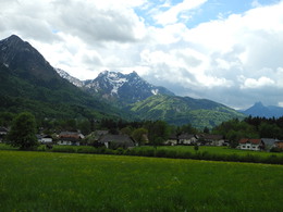
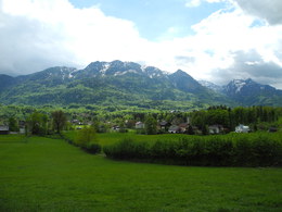
Dammweg Round Walk (Schlüsselloch on the Zimnitz)


- Flatly
Interactive elevation profile
Create PDF
Tour-Details
Path number: 2
Starting place: 4820 Bad Ischl
Destination: 4820 Bad Ischl
duration: 2h 44m
length: 10,3 km
Altitude difference (uphill): 129m
Altitude difference (downhill): 127m
Lowest point: 465m
Highest point: 578m
difficulty: very easy
condition: very easy
panoramic view: Individual Views
Paths covering:
Asphalt, Gravel, Hiking trail
powered by TOURDATA
Lucky Places and the Schüsselloch (Keyhole) on the Zimnitz
Start and end point:
Tourism Office
Trinkhalle
Auböckplatz 5
4820 Bad Ischl
www.badischl.at
(47 ° 42'40 .30 "N - 13 ° 37'24 .30 " O)
Distance: 10.6 km (6.6 km without Schlüsselloch)
Walking time: 3 hours (2 hours without Schlüsselloch)
Difference in altitude: 170 m ascent and descent (with Schüsselloch)
Trail conditions : partly asphalt, some gravel, forest road, few steps
From the starting point, walk through the town centre, to the right of the main church (Stadtpfarrkirche) until just before the bus terminal by the entrance to Kaiservilla and turn left onto the Rechensteg. Shortly after the car park, cross the bridge over the Ischl to Jainzendorfstraße.
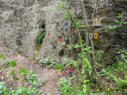
After a few minutes turn left and walk down to the River Ischl .From here follow the gravel path along the river towards Pfandl. After about 15 minutes walk upriver there is a slightly hidden turnoff. By going straight on at this point the circular walk is reduced by a good hour. For the main walk, leave the River Ischl along a narrow path to the right and walk straight ahead through a small area of houses towards the mountains. At a left hand large curve follow the fence of a forest game reserve. Keep going straight on a forest path until reaching houses on the Zimnitz brook. A short distance along the brook is a bridge from where the return route begins. However, continue a further 5 minutes to the Schlüsselloch (keyhole) which is a legendary place to visit on the face of the mountain.
On the way back, initially on the right bank of the stream, the path goes back and forth
(watch for the signs) until it reaches the causeway at the River Ischl. It is now a short distance upstream to the main road in Pfandl (church, pharmacy, ATMs, shops). In a few metres further, on the right hand side, there is a bus stop with return buses to Bad Ischl. Alternatively, to walk back to Bad Ischl, cross to the left on the bridge and follow the steps to the footpath (Dammweg) by the river. Follow this path, with just a brief interruption, right back to the centre of Bad Ischl.
Start and end point:
Tourism Office
Trinkhalle
Auböckplatz 5
4820 Bad Ischl
www.badischl.at
(47 ° 42'40 .30 "N - 13 ° 37'24 .30 " O)
Distance: 10.6 km (6.6 km without Schlüsselloch)
Walking time: 3 hours (2 hours without Schlüsselloch)
Difference in altitude: 170 m ascent and descent (with Schüsselloch)
Trail conditions : partly asphalt, some gravel, forest road, few steps
From the starting point, walk through the town centre, to the right of the main church (Stadtpfarrkirche) until just before the bus terminal by the entrance to Kaiservilla and turn left onto the Rechensteg. Shortly after the car park, cross the bridge over the Ischl to Jainzendorfstraße.
After a few minutes turn left and walk down to the River Ischl .From here follow the gravel path along the river towards Pfandl. After about 15 minutes walk upriver there is a slightly hidden turnoff. By going straight on at this point the circular walk is reduced by a good hour. For the main walk, leave the River Ischl along a narrow path to the right and walk straight ahead through a small area of houses towards the mountains. At a left hand large curve follow the fence of a forest game reserve. Keep going straight on a forest path until reaching houses on the Zimnitz brook. A short distance along the brook is a bridge from where the return route begins. However, continue a further 5 minutes to the Schlüsselloch (keyhole) which is a legendary place to visit on the face of the mountain.
On the way back, initially on the right bank of the stream, the path goes back and forth
(watch for the signs) until it reaches the causeway at the River Ischl. It is now a short distance upstream to the main road in Pfandl (church, pharmacy, ATMs, shops). In a few metres further, on the right hand side, there is a bus stop with return buses to Bad Ischl. Alternatively, to walk back to Bad Ischl, cross to the left on the bridge and follow the steps to the footpath (Dammweg) by the river. Follow this path, with just a brief interruption, right back to the centre of Bad Ischl.
Starting point: Bad Ischl Tourist Board (Trinkhalle)
Destination: Bad Ischl Tourist Board (Trinkhalle)
further information:
- Flatly
")
Most economical season
- Spring
- Summer
- Autumn
Please get in touch for more information.
")
Auböckplatz 5, Trinkhalle
4820 Bad Ischl
Phone +43 6132 27757
E-Mail office@badischl.at
Web www.badischl.at
http://www.badischl.at
Interactive elevation profile
Create PDF
Tour-Details
Path number: 2
Starting place: 4820 Bad Ischl
Destination: 4820 Bad Ischl
duration: 2h 44m
length: 10,3 km
Altitude difference (uphill): 129m
Altitude difference (downhill): 127m
Lowest point: 465m
Highest point: 578m
difficulty: very easy
condition: very easy
panoramic view: Individual Views
Paths covering:
Asphalt, Gravel, Hiking trail
powered by TOURDATA