

Winter hike to St. Lorenz


- All weather
- Suitable for pushchairs
Interactive elevation profile
Create PDF
Tour-Details
Starting place: 5310 Mondsee am Mondsee
Destination: 5310 Mondsee am Mondsee
duration: 2h 4m
length: 8,0 km
Altitude difference (uphill): 71m
Altitude difference (downhill): 71m
Lowest point: 480m
Highest point: 536m
difficulty: easy
condition: easy
panoramic view: Individual Views
Paths covering:
snow
powered by TOURDATA
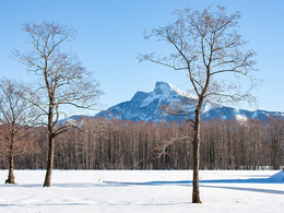
Winter walking trail from Mondsee to St. Lorenz and back.
First, we follow the main road from Mondsee towards St. Gilgen along the lake until we come to a roundabout / Eurospar. There we turn left into the residential area and cross it. Afterwards we walk through a beautiful birch avenue and the residential street of Schwarzindien ("Black India"). Thanks to the private bathing areas on the left hand side, you can always catch a glimpse of the lake. At the end of the residential area we follow the bicycle or Via Nova markings. We follow the path through the meadows straight ahead, walk through the underpass and after the Camaro / Komperdell company building we come to the Wagnermühle riding stables. Now we walk straight ahead along the small path between the paddocks, then briefly right along the street until the former Ischler Bahn line comes right again.
Warning - this road will not be cleared in winter!
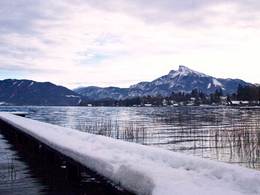
We continue straight along this dam to Höribachstrasse. We follow this road to the Höribachhof and then return on the same way back to Mondsee.
Warning - this road will not be cleared in winter!
We continue straight along this dam to Höribachstrasse. We follow this road to the Höribachhof and then return on the same way back to Mondsee.
Details - hiking
- cleared winter hiking path
- All weather
- Suitable for pushchairs
- Early winter
- Deep winter
Please get in touch for more information.
")
Dr. Franz Müller Straße 3
5310 Mondsee am Mondsee
Phone +43 6232 2270
E-Mail info@mondsee.at
Web www.mondsee.at
http://www.mondsee.at
Interactive elevation profile
Create PDF
Tour-Details
Starting place: 5310 Mondsee am Mondsee
Destination: 5310 Mondsee am Mondsee
duration: 2h 4m
length: 8,0 km
Altitude difference (uphill): 71m
Altitude difference (downhill): 71m
Lowest point: 480m
Highest point: 536m
difficulty: easy
condition: easy
panoramic view: Individual Views
Paths covering:
snow
powered by TOURDATA