

Hinterstoder - Hutterer Böden


- Possible accommodation
Interactive elevation profile
Create PDF
Tour-Details
Path number: 8,217
Starting place: 4573 Hinterstoder
Destination: 4573 Hinterstoder
duration: 3h 23m
length: 5,5 km
Altitude difference (uphill): 817m
Altitude difference (downhill): 10m
Lowest point: 588m
Highest point: 1.398m
difficulty: medium
condition: medium
panoramic view: Some Views
Paths covering:
Hiking trail
powered by TOURDATA
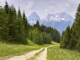
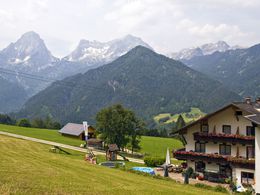
Hike from the town centre of Hinterstoder to the Hutterer Böden. Continue along the foot path and road via the downhill ski track to the road fork nr 217 at the beginning of a high forest. Continue through the forest up to the Schrenkenzieheralm alpine pasture (not managed) and again via the downhill ski track in a few minutes to the wieder Hutterer Böden. Return the same way or by cable car, or via Steyrbergerreith – Wartegg – Hinterstoder village.
Trail-Nr: 8 or AV 217
Trail-Nr: 8 or AV 217
Starting point: center Hinterstoder
Destination: Hutterer Böden
further information:
- Possible accommodation
- Board possible
Accessibility / arrival
Center of Hinterstoder - Tourism Office
Most economical season
- Spring
- Summer
- Autumn
Please get in touch for more information.

Hinterstoder 38
4573 Hinterstoder
Phone +43 7564 5263
Fax machine +43 7564 5263 - 30
E-Mail hinterstoder@pyhrn-priel.net
Web www.urlaubsregion-pyhrn-priel.at
https://www.urlaubsregion-pyhrn-priel.at
Interactive elevation profile
Create PDF
Tour-Details
Path number: 8,217
Starting place: 4573 Hinterstoder
Destination: 4573 Hinterstoder
duration: 3h 23m
length: 5,5 km
Altitude difference (uphill): 817m
Altitude difference (downhill): 10m
Lowest point: 588m
Highest point: 1.398m
difficulty: medium
condition: medium
panoramic view: Some Views
Paths covering:
Hiking trail
powered by TOURDATA