

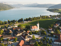
Westwanderweg from Seewalchen to Attersee


- pets allowed
- All weather
- Suitable for families
- Suitable for kids (all ages)
- culturally interesting
- Possible accommodation
Interactive elevation profile
Create PDF
Tour-Details
Starting place: 4863 Seewalchen am Attersee
Destination: 4864 Attersee am Attersee
duration: 3h 18m
length: 11,1 km
Altitude difference (uphill): 281m
Altitude difference (downhill): 286m
Lowest point: 472m
Highest point: 787m
difficulty: medium
condition: medium
panoramic view: Great panorama
Paths covering:
Asphalt, Gravel, Hiking trail
powered by TOURDATA
Beautiful hike along the Westwanderweg from Seewalchen to Attersee am Attersee. Along the hiking trail you will pass beautiful villas and enjoy an incredibly beautiful landscape! There is also the possibility to combine the hike with the Attersee boat trip.
It goes along the promenade to Villa Paulick (part of the Gustav Klimt Theme Trail) and from here to the parish church of Seewalchen. There you turn left onto the Schulweg (Zeitleistenweg) and follow the yellow signs along a forest path to the Ginzkey-Weg until you reach the Ginzkey memorial (Franz Karl Ginzkey, a well-known Austrian writer and poet who spent the summer months in Seewalchen).
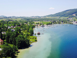
The trail continues through the forest across the "Mooser Feld" to the village of Litzlberg. Here you will find the recreation area with lido, beach volleyball court and children's playground as well as the Kammersee sailing club. The path continues through meadows, fields and small settlements to Buchberg (old, thousand-year-old church). After a short stretch along the road, turn right. Here, during the gentle ascent to Haining, beautiful panoramic views of the Attersee and the Höllengebirge mountains are offered. Once in Haining, you walk past the riding hall through the village of Berg to the imposing Buchberg (808 m). From there you can enjoy a wonderful panoramic view of the entire Attersee-Attergau region. This is also where the descent to Attersee begins.
From Attersee you can take the boat back to Seewalchen in summer.
For ship schedule you can see here
Refreshment stops:
In all hotels, inns, restaurants and cafes in Seewalchen am Attersee and Attersee am Attersee.
Refreshments:
Hotel-Restaurant Litzlberger Keller, Tel +43 7662 2312
Café-restaurant Kalleitner, Litzlberg - Tel +43 7662 8066
Stadlwirt z `Haining, Haining - Tel +43 7662 8561
It goes along the promenade to Villa Paulick (part of the Gustav Klimt Theme Trail) and from here to the parish church of Seewalchen. There you turn left onto the Schulweg (Zeitleistenweg) and follow the yellow signs along a forest path to the Ginzkey-Weg until you reach the Ginzkey memorial (Franz Karl Ginzkey, a well-known Austrian writer and poet who spent the summer months in Seewalchen).
The trail continues through the forest across the "Mooser Feld" to the village of Litzlberg. Here you will find the recreation area with lido, beach volleyball court and children's playground as well as the Kammersee sailing club. The path continues through meadows, fields and small settlements to Buchberg (old, thousand-year-old church). After a short stretch along the road, turn right. Here, during the gentle ascent to Haining, beautiful panoramic views of the Attersee and the Höllengebirge mountains are offered. Once in Haining, you walk past the riding hall through the village of Berg to the imposing Buchberg (808 m). From there you can enjoy a wonderful panoramic view of the entire Attersee-Attergau region. This is also where the descent to Attersee begins.
From Attersee you can take the boat back to Seewalchen in summer.
For ship schedule you can see here
Refreshment stops:
In all hotels, inns, restaurants and cafes in Seewalchen am Attersee and Attersee am Attersee.
Refreshments:
Hotel-Restaurant Litzlberger Keller, Tel +43 7662 2312
Café-restaurant Kalleitner, Litzlberg - Tel +43 7662 8066
Stadlwirt z `Haining, Haining - Tel +43 7662 8561
Starting point: Promenade (section of the Gustav Klimt Theme Trail) or parish church in Seewalchen am Attersee
Destination: Local center Attersee am Attersee
further information:
- Possible accommodation
- Board possible
The road is generally accessible all year round, but is not cleared in winter!
")
")
")
")
")
Accessibility / arrival
Car:
From Salzburg via the A1 - exit Seewalchen
From Vienna/Linz via A1 - exit Schörfling or Seewalchen
From the west - Bad Ischl-Weißenbach-Steinbach-Weyregg-Schörfling
By train:
Coming from Salzburg or Linz/Vienna to Attnang-Puchheim or Vöcklabruck - continue with the Kammer Bahn to BH Kammer Schörfling or with the bus stop Kammer-Agerbrücke or Seewalchen-Agerbrücke.
Plane:
From Salzburg via A1 - exit Seewalchen
From Vienna/Linz via A1 - exit Schörfling or Seewalchen
- Parking space: 10
- All weather
- Suitable for groups
- Suitable for schools
- Suitable for kids (6 - 14 Year)
- Suitable for kids (all ages)
- Pets allowed
- Suitable for teenagers
- Suitable for seniors
- Suitable for single travelers
- Suitable for friends
- Suitable for couples
- Suitable for children
- Spring
- Summer
- Autumn
- Early winter
Please get in touch for more information.
")
Dorfstraße 33
4865 Nußdorf am Attersee
Phone +43 7666 7719 - 40
E-Mail info.schoerfling@attersee.at
Web attersee-attergau.salzkammergut.at
https://attersee-attergau.salzkammergut.at
You can also visit us on
Visit us on Facebook Visit us on Instagram Visit us on Pinterest Visit our videochannel on YouTube Wikipedia")
")
")
")
")
")
")
")
Interactive elevation profile
Create PDF
Tour-Details
Starting place: 4863 Seewalchen am Attersee
Destination: 4864 Attersee am Attersee
duration: 3h 18m
length: 11,1 km
Altitude difference (uphill): 281m
Altitude difference (downhill): 286m
Lowest point: 472m
Highest point: 787m
difficulty: medium
condition: medium
panoramic view: Great panorama
Paths covering:
Asphalt, Gravel, Hiking trail
powered by TOURDATA