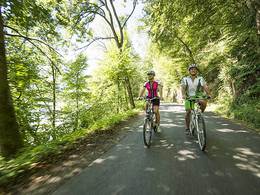
Radweg II "Rund um den Buchberg" Nr. 909


- culinary interesting
- culturally interesting
- Flatly
- Possible accommodation
Interactive elevation profile
Create PDF
Tour-Details
Path number: 909
Starting place: 4291 Lasberg
Destination: 4291 Lasberg
duration: 6h 28m
length: 22,9 km
Altitude difference (uphill): 453m
Altitude difference (downhill): 457m
Lowest point: 559m
Highest point: 837m
difficulty: easy
condition: easy
panoramic view: Some Views
Paths covering:
Asphalt
powered by TOURDATA
The cycle route leads in the direction of Elz. Approx. 2 km after Lasberg you come to the village of Punkenhof. There you have the opportunity to take a half-hour hike along hiking trails 170 and LA 5 to the newly built "Hohhaus" viewing platform on the Buchberg. The marvellous view over the hilly landscape of the Mühlviertel from the Bohemian Forest to the Alps is enchanting.
A stop at the rustic GH Seppnwirt is well worthwhile.
You can also visit the Kreindl family's private Kernland Museum in Grieb, Weinberg Castle in Kefermarkt and the world-famous winged altar in Kefermarkt parish church.
We now ride along the railway and the small, romantic Feldaist river directly to the Gasthof zur Haltestelle. For motorbike enthusiasts and those who would like to become one, there is the opportunity to visit a private Puch motorbike collection. Then it's back to Lasberg.
Here you can take a detour to the "Fürstenhammer" open-air museum and Dornach Castle.
Most economical season
- Spring
- Summer
- Autumn
Please get in touch for more information.
Markt 26
4291 Lasberg
Phone +43 7947 7255 - 13
E-Mail tourismuskern@lasberg.at
Web www.lasberg.at
Web www.muehlviertel-urlaub.at/rad
https://www.lasberg.at
https://www.muehlviertel-urlaub.at/rad
https://www.muehlviertel-urlaub.at/rad
Interactive elevation profile
Create PDF
Tour-Details
Path number: 909
Starting place: 4291 Lasberg
Destination: 4291 Lasberg
duration: 6h 28m
length: 22,9 km
Altitude difference (uphill): 453m
Altitude difference (downhill): 457m
Lowest point: 559m
Highest point: 837m
difficulty: easy
condition: easy
panoramic view: Some Views
Paths covering:
Asphalt
powered by TOURDATA


