

Tolerance trail


- Flatly
Interactive elevation profile
Create PDF
Tour-Details
Paths covering:
In the footsteps of the secret Protestants - the once mysterious, hidden path invites today to a leisurely hike of about 1.5 hours. In addition to the wonderful panorama of the surrounding mountains, this thematic trail should above all teach and warn that the freedom of faith is not a matter of course.
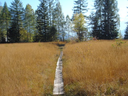
The Tolerance path - a leisurely hike
The approx. 2 km long Tolerance track is well signposted, but only accessible with good tracking shoes. With a walking time of about 1.5 hours, it is one of the easy hiking trails in the region. But it offers a wonderful mountain panorama and also a special place of happiness: the Schwarzenbachloch cave.
The starting point is the parking lot “Flohwiesen”. The track starts on an asphalt road until you turn right at the marker. You walk over a field towards the forest. After the forest is passed, it goes over a meadow, where a beautiful mountain panorama and a rest area wait. Then you continue through the forest until you reach the steep but short climb to the Schwarzenbachloch cave. For the approx. 100 m2 large cave a flashlight is recommended.
The Schwarzenbachloch cave is one of the three caves in which the Protestant religious community regularly celebrated their secret church services at the time of the re-catholization.
The path continues at the right of the cave up to a forest road. Here you can hike left to “Hütteneck” or in about 15 minutes’ walk back to the parking lot.
The freedom of belief
The Tolerance Trail invites you to take a journey through time to the most important points of the Protestant history in the Salzkammergut. A hike not only in the beautiful nature, but also in the history of faith in the Salzkammergut.
For more than 80 years, the Protestant faith flourished in the Salzkammergut until it was strictly forbidden by the Habsburgs. Externally Catholic, Protestantism developed over six generations as an underground church, persecuted by the authorities. The meeting places were natural caves such as the Seekarkirche in Gosau at Dachstein, the Kalmooskirche on the Kalmberg and the Schwarzenbachloch cave.
For two centuries, the evangelicals were persecuted and expelled. Many families were forced to emigrate to Siebenbürgen in Romania. In 1781 King Joseph II issued the tolerance patent. After the end of the cruel era of the Counter-Reformation, Goiserer people could found a Protestant church that included 1117 people only one year later.
If your are searching for more hiking trails, check out the hiking site of the Dachstein Salzkammergut.
Order hiking maps to the Dachstein Salzkammergut region ...
For a 360 ° panorama tour through Bad Goisern ...
In emergency call the mountain rescue on 140
further information:
- Flatly
Details - hiking
- themed path
From Bad Goisern on the B145 in the direction of St. Agatha. In the village St. Agatha behind the petrol station turn left towards Halleralm. Follow the signs to the parking lot "Flohwiese" in Pichlern.
- Parking space: 25
free of charge
- Summer
Please get in touch for more information.
4822 Bad Goisern am Hallstättersee
Phone +43 6135 8329
Fax machine +43 6135 8329 - 74
E-Mail goisern@dachstein-salzkammergut.at
Web www.wandern-dachstein.at
Web www.dachstein-salzkammergut.at
http://www.dachstein-salzkammergut.at
You can also visit us on
Visit us on Facebook Visit us on Instagram Visit us on Pinterest Visit our videochannel on YouTube Wikipedia Blog")
")
")
")
Interactive elevation profile
Create PDF
Tour-Details
Paths covering: