

Buchberg climb to the Jagastüberl


- Suitable for families
- Flatly
Interactive elevation profile
Create PDF
Tour-Details
Starting place: 4880 St. Georgen im Attergau
Destination: 4880 St. Georgen im Attergau
duration: 1h 33m
length: 4,9 km
Altitude difference (uphill): 170m
Altitude difference (downhill): 173m
Lowest point: 642m
Highest point: 774m
difficulty: medium
condition: medium
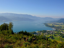
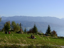
panoramic view: Great panorama
Paths covering:
Asphalt, unfixed, Hiking trail
powered by TOURDATA
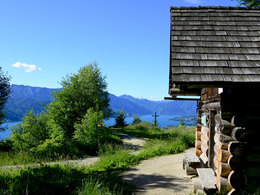
Very nice hike to the rest area at the Jägerstüberl (refuge) with views over the Attersee and the Höllengebirge mountains behind. Ideally suited as a short family hike.
We would like to emphasize that the Buchberg is released by the forest administration Mayr Melnhof only for hikers! Cycling on the forest roads and hiking trails on the Buchberg, however, is prohibited.
Get inspired now and try out the 360° Perspectives Tour! The start of this hike is the parking lot in Alkersdorf. From here, the trail initially leads briefly along the asphalt road, then up the steep meadow to the right and continues through the forest and across the unique grassy landscape of the Buchberg to the Jägerstüberl, where you can enjoy magnificent views of Lake Attersee and the Attergau landscape.
For families, the ascent is suitable via path 4 Buchberg, which leads from the parking lot Alkersdorf on an asphalt road up to the summit and is also suitable for strollers.
Back you have several options to extend the tour (see hiking map and signage) or take the same path back to the starting point.
REFRESHMENT STOPS:
Mostheuriger Zeininger, Eisenpalmsdorf,
After a short construction period, the new parking lot with about 30 parking spaces for hikers on and around the Buchberg was completed. Particularly important was with the new building to prevent the Wildparken in such a way, which increased in the last years massively. We are very pleased to have found an ideal solution here together with the property owner and would like to take this opportunity to thank the Gruber family and the municipality of St. Georgen im Attergau for the good cooperation and support during the realization.
Accessibility / arrival
By car:
From Salzburg via motorway A1 – Exit St. Georgen im Attergau – right on the Attergaustraße
(L540) to the center.
From Vienna/Linz via motorway A1 – Exit St. Georgen im Attergau – right on the
Attergaustraße (L540) to the center.
From Bad Ischl – Weißenbachtal (B153) – follow B152 to Unterach and then B151 to
Attersee than left to the Attergaustraße (L540) to St. Georgen.
By train:
From Salzburg or Linz/Vienna with „Austrian Federal Railways“ or „Westbahn“ to Attnang
Puchheim - via regional train to Vöcklamarkt and St. Georgen
By plane:
Arrival to Airport Salzburg or Linz – with the car/bus or train to St. Georgen im Attergau.
- Parking space: 30
- Suitable for teenagers
- Suitable for seniors
- Suitable for single travelers
- Suitable for friends
- Suitable for couples
- Suitable for children
- Spring
- Summer
- Autumn
- Early winter
Please get in touch for more information.
Attergaustaße 55
4880 St. Georgen im Attergau
Phone +43 7666 7719 - 80
E-Mail info.attergau@attersee.at
Web attersee-attergau.salzkammergut.at
https://attersee-attergau.salzkammergut.at
You can also visit us on
Visit us on Facebook Visit us on Instagram Visit us on Pinterest Visit our videochannel on YouTube Wikipedia
")
Interactive elevation profile
Create PDF
Tour-Details
Starting place: 4880 St. Georgen im Attergau
Destination: 4880 St. Georgen im Attergau
duration: 1h 33m
length: 4,9 km
Altitude difference (uphill): 170m
Altitude difference (downhill): 173m
Lowest point: 642m
Highest point: 774m
difficulty: medium
condition: medium
panoramic view: Great panorama
Paths covering:
Asphalt, unfixed, Hiking trail
powered by TOURDATA