

Traverse of the Sarstein from Bad Goisern to Obertraun


- pets allowed
- Suitable for families
Interactive elevation profile
Create PDF
Tour-Details
Paths covering:
Exhausting and in places quite steep, but not particularly difficult mountain tour to one of the most beautiful view peaks in the Salzkammergut.
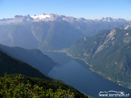
The number 1 in the matter of view!
Hiking professionals agree: The Hohe Sarstein is the most beautiful view mountain in the Inner Salzkammergut. Up there is the only opportunity to catch the Dachstein glacier and Lake Hallstatt in one view - not to speak of the rest of the panorama over the lakes of the Ausseerland to the Tote Gebirge and the distant Wiesbachhorn (Hohe Tauern).
The resolute Koppentraun, which rushes up from its 1400 m deep groove to the summit cross, provides the accompanying music. And the best thing about it: On the descent towards Obertraun, you can still enjoy the panorama for almost 2 km!
From the railway station Steeg-Gosau walk to the nearby railroad crossing, turn left and walk next to the main road into the nearby village of Au. After the Landgasthof "Zur Post" turn right and walk along Erlenstraße to St. Agatha. Turn right onto the main road, after the bridge go left across the roadway and up the old, in places steep Pötschenstraße through the village of Sarstein. At the turnoff next to a memorial stone, continue left. Soon after, turn right onto the signposted and marked trail no. 690 to Sarstein and cross the Pötschenstraße again (if you are descending on the following route, you can also start here at the parking Pötschenpass).
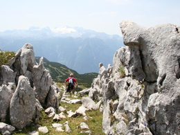
Follow the marked forest path uphill. From the former "Simony view" you cross into the deeply cracked Rotengraben, next to which you then climb very steeply and in many serpentines to the mountain pasture "Sarsteinalm". Continue briefly to a saddle and branch off to the right onto trail no. 692 and up through a rocky flank to a small gate. Finally, walk across the grassy slopes to the summit cross.
On the descent you continue to follow path no. 692, which descends southwards over 2 km. Across alpine meadows you reach the Sarstein hut. Afterwards you descend over a steep forest ridge and then turn left through the hillside. Finally, you descend steeply in many serpentines next to the Brettsteingraben to Obertraun.
In case of emergency call the mountain rescue under 140!
Order hiking maps to the Holiday Region Dachstein Salzkammergut ...
Experience the 360 degree live panorama of Bad Goisern....
further information:
- Board possible
From about the end of May to October (depending on the weather)
Start on arrival by train at railway station Steeg-Gosau or by car at parking Pötschenpass.
by car
from Salzburg:
Exit Thalgau via federal road B158 towards Bad Ischl, in Bad Ischl drive onto Salzkammergut Street B145 towards Bad Goisern
from Linz:
Exit Regau via federal road Salzkammergut street B145 towards Gmunden and Bad Ischl to Bad Goisern
from Vienna/Graz:
Exit Liezen via federal road B320, in Trautenfels drive onto Salzkammergut street B145 towards Bad Goisern
from Villach:
Tauern motorway to exit "Eben im Pongau", via B166 Pass Gschütt federal road through Gosau, at the Gosaumühle junction turn towards Bad Goisern
by train
Attnang-Puchheim - Stainach-Irdning lines
stop "Steeg / Gosau"
by bus
Bus 542 (Bad Ischl - Gosausee)
stop St. Agatha Agathawirt
Detailed information on the respective train and bus times can be found at https://www.oebb.at/en/ (train) and https://www.postbus.at/en (bus).
- Parking space: 30
- Bus parking space: 2
- Suitable for groups
- Pets allowed
- Suitable for single travelers
- Suitable for friends
- Suitable for couples
- Summer
- Autumn
Please get in touch for more information.
Kirchengasse 4
4822 Bad Goisern am Hallstättersee
Phone +43 5 95095 - 10
Fax machine +43 5 59095 - 74
E-Mail goisern@dachstein-salzkammergut.at
Web www.dachstein-salzkammergut.at
Web www.wandern-dachstein.at
http://www.wandern-dachstein.at
You can also visit us on
Visit us on Facebook Visit us on Instagram Visit us on Pinterest Visit our videochannel on YouTube WikipediaInteractive elevation profile
Create PDF
Tour-Details
Paths covering: