

Through the Koppenwinkel


- Suitable for families
- Suitable for pushchairs
- Flatly
Interactive elevation profile
Create PDF
Tour-Details
Paths covering:
Theme trail with small wonders of nature
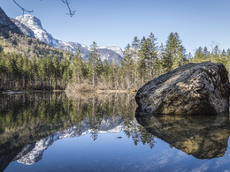
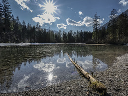
Constant dripping wears the stone - and brings about all sorts of other wondrous things. This can be seen in the Koppenwinkl, a romantic area under the giant walls of the Dachstein massif, where a theme trail puts the small wonders of nature in the right light.
The tour:
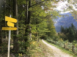
From the railway station Obertraun Dachsteinhöhlen you walk past the catholic church and directly up the Stiegergasse to the hiking trail Höhenweg No. 1, which leads above the village through the Sarstein forest to the railway station Obertraun Koppenbrüllerhöhle. Continue over the Traun Bridge. You should not miss a visit of the Koppenbrüller Cave.
The Koppenbrüller Cave is the youngest of the Dachstein Caves and shows you the unexpected course of the water in the Dachstein mountains. Depending on the weather situation that prevails at the top of the Dachstein mountains, you can actually hear the cool water of the active water cave roaring more or less strongly.
Behind the inn Koppenrast, one of the best culinary addresses in the Salzkammergut, you turn right to the holiday camp "Kinderfreunde" and then hike to the Lake Koppenwinkl.
Continue on the forest road to the mountain pasture Koppenwinkl, then turn right and follow the hiking trail no. 2 over the Hagen and Bühler brooks. Then cross the river Traun and take hiking trail no. 6 along the river. On the signposted Höll-Karl-Weg you walk past the sports field, cross the railway crossing to Koppenstreet and turn left back to the railway station.
The Inner Salzkammergut is an Eldorado for big and small cave explorers. In the depths of the mountain world you can, mostly guided, penetrate the widely ramified underground network.
As highlights we suggest a visit to the Dachstein Giant Ice Cave (one of the largest ice caves on earth) as well as the Mammoth Cave.
Experience a 360° panorama tour through Obertraun…
Order hiking maps of the Dachstein Salzkammergut Region ...
Mountain rescue: 140
further information:
- Flatly
- Board possible
by car
from Salzburg:
Federal road B158 direction Bad Ischl
in Bad Ischl driveway onto Salzkammergut Straße B145 in direction to Bad Goisern, Hallstatt and Obertraun
from Linz:
A1 motorway exit Regau on Salzkammergut Straße B145 direction Gmunden, Bad Goisern, Hallstatt and Obertraun
from Graz:
A9 motorway exit Liezen on B320
in Trautenfels turn onto Salzkammergut Straße B145 via Bad Aussee to Obertraun
from Villach:
A10 Tauernautobahn to exit "Eben im Pongau", from there via Annaberg, Gosau and Hallstatt to Obertraun
by bus:
get off at the bus station “Obertraun Feriendorf”
by train:
from Linz/Salzburg to Attnang-Puchheim, change to train to Stainach-Irdning
or from Stainach-Irdning Zug direction Attnang-Puchheim
get off at train station "Obertraun-Dachsteinhöhlen"
Detailed information on the respective train and bus times can be found at https://www.oebb.at/en/ (train) and https://www.postbus.at/en (bus).
- Parking space: 8
free of charge
- Suitable for groups
- Suitable for schools
- Suitable for pushchairs
- Suitable for teenagers
- Suitable for seniors
- Suitable for single travelers
- Suitable for friends
- Suitable for couples
- Suitable for children
- Spring
- Summer
- Autumn
Please get in touch for more information.
Obertraun 180
4831 Obertraun
Phone +43 5 95095 - 40
E-Mail obertraun@dachstein-salzkammergut.at
Web www.dachstein-salzkammergut.at
Web www.wandern-dachstein.at
http://www.wandern-dachstein.at
You can also visit us on
Visit us on Facebook Visit us on Instagram Visit us on Pinterest Visit our videochannel on YouTube Wikipedia")
")
")
")
Interactive elevation profile
Create PDF
Tour-Details
Paths covering: