

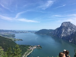
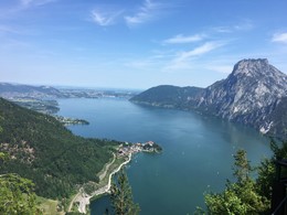
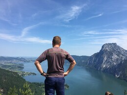
Rondwandeling Kleiner Sonnstein - Großer Sonnstein - Ebensee - Traunkirchen


- pets allowed
- Flatly
Interactive elevation profile
Create PDF
Tour-Details
Starting place: 4801 Traunkirchen
Destination: 4801 Traunkirchen
duration: 4h 55m
length: 8,7 km
Altitude difference (uphill): 851m
Altitude difference (downhill): 849m
Lowest point: 424m
Highest point: 1.012m
difficulty: medium
condition: medium
panoramic view: Dreamtour
Paths covering:
Asphalt, Climbing mount, unfixed, Hiking trail
powered by TOURDATA
Walking time: 4,5 - 5 h
Route Number: 1
Highest point: 1037m
Refreshments: hut Sonnsteinhütte of the Mountain Rescue Services of Traunkirchen (from Easter to the end of October saturdays, sundays and at holidays, from the holiday-beginning: July and August daily open. Tel.: 0664/8797294)
restaurants in Ebensee starting point: town square in Traunkirchen
drive or go on the main street approximately 1 km in southern direction (direction to Ebensee) - in front of the first tunnel right upwards across numerous steps - follow the path - at the intersection to the left through the forest you reach the small "Sonnstein - to the right you will reach the "Großer Sonnstein" - along a mountain crest - left uphill across a step in the cliff secured by a rope to the summit of the "Großer Sonnstein" - back to the fork in the path - left onto the path in the direction of Ebensee - descent via the Bartlberg and past the Catholic parish church into the center of Ebensee
Return to Traunkirchen by train, ship, bus or by foot along the Salzkammergut Cycling Route via the old main road to Traunkirchen Ort (by foot: walking time about 1 hour)
Parking
- Parking space: 20
- Pets allowed
- Suitable for single travelers
- Spring
- Summer
- Autumn
Please get in touch for more information.
4801 Traunkirchen
Phone +43 650 3048617
E-Mail office@bergrettung-traunkirchen.at
Web www.sonnsteinhuette.at
http://www.sonnsteinhuette.at
")
Interactive elevation profile
Create PDF
Tour-Details
Starting place: 4801 Traunkirchen
Destination: 4801 Traunkirchen
duration: 4h 55m
length: 8,7 km
Altitude difference (uphill): 851m
Altitude difference (downhill): 849m
Lowest point: 424m
Highest point: 1.012m
difficulty: medium
condition: medium
panoramic view: Dreamtour
Paths covering:
Asphalt, Climbing mount, unfixed, Hiking trail
powered by TOURDATA