

Höss Circular Trail (Circular Hiking World Hinterstoder)


- Flatly
Interactive elevation profile
Create PDF
Tour-Details
Starting place: 4573 Hinterstoder
Destination: 4573 Hinterstoder
duration: 0h 45m
length: 2,4 km
Altitude difference (uphill): 77m
Altitude difference (downhill): 79m
Lowest point: 1.805m
Highest point: 1.882m
difficulty: medium
condition: medium
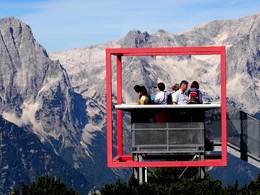
panoramic view: Dreamtour
Paths covering:
Gravel, Hiking trail
powered by TOURDATA
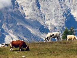
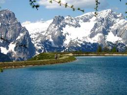
Starting point of the Höss Circular Trail is the top station of the Höss Express at approx. 1.800 m above sea level. The circular trail leads along a practically level path through the lush alpine meadows and alpine bushes – called „Latschen“ (needle bushes) and rises gently through the „Latschen Labyrinth“ to the so-called Schneeofen (snow oven) along the south-eastern edge of the terrain. The alpine meadow path takes a south-westerly direction at a later stage, crosses the alpine path to the Schrockengrat ridge and leads slightly uphill again to the viewing platform „Dachsteinblick“. From here the path continues downhill: meandering through alpine needle bushes in downhill serpentines to the fascinating view of the two most prominent peaks, Great Priel and Spitzmauer (pointed wall), also reflected in the waters of the Schafkogel Lake. From the lake the path passes a small mountain chapel and leads back to the mountain restaurant Berggasthof Höss and further to the top station of the 6-person chair lift, the Höss Express.
Starting point: Mountain station to the Höss Express Hutterer Höss
Destination: Mountain station to the Höss Express Hutterer Höss
further information:
- Flatly
- Board possible
Details - hiking
- themed path
")
Accessibility / arrival
From the center of Hinterstoder, take the 6 person cabin railway and the Höss-Express 6-seater chair lift to the starting point of the Höss-round. Parking at the large car park at the beginning of Hinterstoder.
Most economical season
- Spring
- Summer
- Autumn
Please get in touch for more information.

Hinterstoder 38
4573 Hinterstoder
Phone +43 7564 5263
Fax machine +43 7564 5263 - 30
E-Mail hinterstoder@pyhrn-priel.net
Web www.urlaubsregion-pyhrn-priel.at
https://www.urlaubsregion-pyhrn-priel.at
Interactive elevation profile
Create PDF
Tour-Details
Starting place: 4573 Hinterstoder
Destination: 4573 Hinterstoder
duration: 0h 45m
length: 2,4 km
Altitude difference (uphill): 77m
Altitude difference (downhill): 79m
Lowest point: 1.805m
Highest point: 1.882m
difficulty: medium
condition: medium
panoramic view: Dreamtour
Paths covering:
Gravel, Hiking trail
powered by TOURDATA