

Öttl Circular Trail (Circular Hiking World Hinterstoder)


- Flatly
Interactive elevation profile
Create PDF
Tour-Details
Path number: 9,201
Starting place: 4573 Hinterstoder
Destination: 4573 Hinterstoder
duration: 1h 39m
length: 5,0 km
Altitude difference (uphill): 202m
Altitude difference (downhill): 197m
Lowest point: 590m
Highest point: 741m
difficulty: easy
condition: easy
panoramic view: Some Views
Paths covering:
Gravel, Hiking trail
powered by TOURDATA
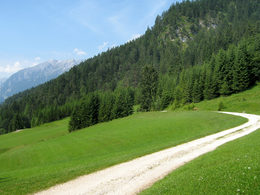
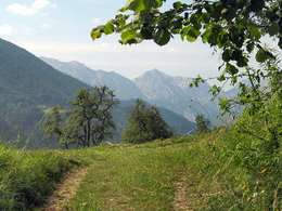
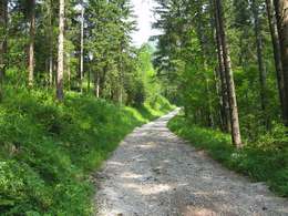
On the sunny side of the valley, close to the beginning of the Hametner path and only a few walking minutes from the centre of the village you will find a gravel road leading into the side valley of the Steger stream. A brief steep climb gets you to a wood glade after which you turn left towards the sunny slopes of the Öttl mountain. Follow the markings along romantic forest and meadow paths with a slight climb until you reach the Öttl farm. From there a gravel road leads down into the valley, crossing a few ditches and streams on the way leading westwards through a pine forest ending between the Schiederweiher pond and the Johannishof farm, merging with the Polsterlucken Circular Trail. From there follow the Flötzer path back to your starting point in the centre of the village.
Starting point: House Hametner Hinterstoder - Jutel Hinterstoder passing over the bridge
Destination: House Hametner Hinterstoder - Jutel Hinterstoder passing over the bridge
further information:
- Flatly
Details - hiking
- themed path
Accessibility / arrival
The starting point is the center of Hinterstoder.
Most economical season
- Spring
- Summer
- Autumn
Please get in touch for more information.

Hinterstoder 38
4573 Hinterstoder
Phone +43 7564 5263 - 99
Fax machine +43 7564 5263 - 30
E-Mail hinterstoder@pyhrn-priel.net
Web www.urlaubsregion-pyhrn-priel.at
http://www.urlaubsregion-pyhrn-priel.at
Interactive elevation profile
Create PDF
Tour-Details
Path number: 9,201
Starting place: 4573 Hinterstoder
Destination: 4573 Hinterstoder
duration: 1h 39m
length: 5,0 km
Altitude difference (uphill): 202m
Altitude difference (downhill): 197m
Lowest point: 590m
Highest point: 741m
difficulty: easy
condition: easy
panoramic view: Some Views
Paths covering:
Gravel, Hiking trail
powered by TOURDATA