

Vorderstoder - Strumboding


Interactive elevation profile
Create PDF
Tour-Details
Path number: 9
Starting place: 4574 Vorderstoder
Destination: 4573 Hinterstoder
duration: 2h 0m
length: 6,0 km
Altitude difference (uphill): 204m
Altitude difference (downhill): 430m
Lowest point: 556m
Highest point: 821m
difficulty: medium
condition: medium
panoramic view: Some Views
Paths covering:
Asphalt, Gravel, Hiking trail
powered by TOURDATA
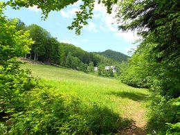
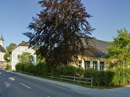
The trail leads via meadows and through forests downhills to „Schönau“ - continue along nr. 34 further downhills along a forest road. The trail leads like nr. 7 to Unterbucheben at Vorderstoder and then continues after about 150 m (HT) direction Zamseggergut (farm). From there take the access road down to the main road and turn right. After another 100m the marked trail (HT) turns off through the forest to the Lugisgut farm. Continue along nr.9 close to the Stensberg farmhouse.
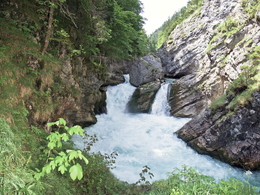
After the first bend turn left onto a forest path and follow nr. 34 crossing the main road to the Stromboding waterfall.
Along the main road you reach Hinterstoder in about 20 minutes to get to the bus station (turn off to Vorderstoder).
Perservering hikers can continue along the road to Vorderstoder and turn right after about 10 min (HT) to follow nr. 1 uphills to the Wartegg farm and to Vorderstoder (walking time from Stromboding about 2,5 hrs).
Trail-Nr: 9
Starting point: Municipal office Vorderstoder
Destination: Parking Strumboding waterfall Hinterstoder
Accessibility / arrival
by car:
Motorway A1 to A9, exit Voralpenkreuz Hinterstoder, country road to Hinterstoder - 200 meters after the sign turn left to Vorderstoder Hinterstoder (approx 5 km).
by train:
Pyhrnbahn stop Windischgarsten (10 km) or Hinterstoder (15 km) -> from the place
Most economical season
- Spring
- Summer
- Autumn
Please get in touch for more information.

Vorderstoder 66
4574 Vorderstoder
Phone +43 7564 8255
Fax machine +43 7564 8255 - 20
E-Mail vorderstoder@pyhrn-priel.net
Web www.urlaubsregion-pyhrn-priel.at
http://www.urlaubsregion-pyhrn-priel.at
Interactive elevation profile
Create PDF
Tour-Details
Path number: 9
Starting place: 4574 Vorderstoder
Destination: 4573 Hinterstoder
duration: 2h 0m
length: 6,0 km
Altitude difference (uphill): 204m
Altitude difference (downhill): 430m
Lowest point: 556m
Highest point: 821m
difficulty: medium
condition: medium
panoramic view: Some Views
Paths covering:
Asphalt, Gravel, Hiking trail
powered by TOURDATA