

Dolomitensteig Climb


- Suitable for families
- Flatly
Interactive elevation profile
Create PDF
Tour-Details
Path number: Beschilderung Dolomitensteig
Starting place: 4573 Hinterstoder
Destination: 4573 Hinterstoder
duration: 4h 50m
length: 8,8 km
Altitude difference (uphill): 827m
Altitude difference (downhill): 832m
Lowest point: 709m
Highest point: 1.379m
difficulty: medium
condition: medium
panoramic view: Dreamtour
Paths covering:
Climbing mount, Hiking trail
powered by TOURDATA
roadblock: Akutmeldung/Sperre
Description: The Dolomitensteig is closed every year from 15 September to 01 October for hunting reasons.
Start and finish of this beautiful panorama hike is the tavern of Baumschlagerreith situated at the end of the Stodertal Valley.
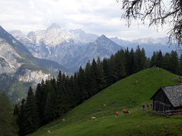
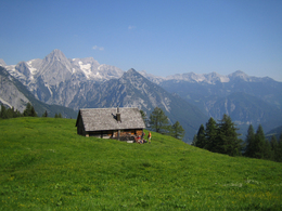
From the parking area at the Baumschlagerreith tavern (724m above sea-level) walk along the right hand side of the game enclosure along the forest road for about 500m until you reach the sign „Hochsteinalm“. Continue along a small path to the actual trail of the Hochsteinalmsteig (Nr. 19), which leads in steap serpentines up to the Hochsteinalm alpine hut (1296m above sea-level/not managed). Once you reach the Hochsteinalm alpine hut, you can already see the Lögeralm alpine hut (not managed) to your top right, which you can reach within 10 minutes of walk.
Take time for a break and enjoy the stunning views. Above the Lögeralm hut you will find the starting point of the Stodertaler Dolomitensteig (high alpine climb) .
High Alpine Experience necessary – must be free from giddiness!
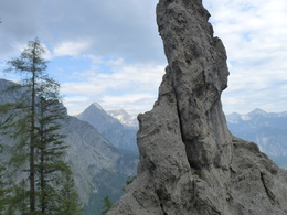
The climb continues along the steep walls without much up and down. The landscape becomes bizarre and some tricky passages are secured with steel ropes. At the most difficult spot, the descent towards 'Schwarzgraben' , you will reach the Gumpenkaskaden (cascades) with beautiful water falls. The rock pools are filled with crystal clear water and the panoramic view is indescribably beautiful - bizarre rock formations mixed with breathtaking alpine scenery.
From now on the path is easier, leading through a forest until you reach the so called Poppensand – a huge pebble field. Go down the pebble field to get back to the marked trail of the Salzsteigjoch. The last part of the hike leads along a forest road back to the tavern of Baumschlagerreith.
An absolute culinary highlight at the tavern is the smoked stag ham, the perfect way to end this experience.
Current signage: red-white-red signs, partly marked „Dolomitensteig“
Attention: Closed for hunting from 15. September to 1. October!
From the parking area at the Baumschlagerreith tavern (724m above sea-level) walk along the right hand side of the game enclosure along the forest road for about 500m until you reach the sign „Hochsteinalm“. Continue along a small path to the actual trail of the Hochsteinalmsteig (Nr. 19), which leads in steap serpentines up to the Hochsteinalm alpine hut (1296m above sea-level/not managed). Once you reach the Hochsteinalm alpine hut, you can already see the Lögeralm alpine hut (not managed) to your top right, which you can reach within 10 minutes of walk.
Take time for a break and enjoy the stunning views. Above the Lögeralm hut you will find the starting point of the Stodertaler Dolomitensteig (high alpine climb) .
High Alpine Experience necessary – must be free from giddiness!
The climb continues along the steep walls without much up and down. The landscape becomes bizarre and some tricky passages are secured with steel ropes. At the most difficult spot, the descent towards 'Schwarzgraben' , you will reach the Gumpenkaskaden (cascades) with beautiful water falls. The rock pools are filled with crystal clear water and the panoramic view is indescribably beautiful - bizarre rock formations mixed with breathtaking alpine scenery.
From now on the path is easier, leading through a forest until you reach the so called Poppensand – a huge pebble field. Go down the pebble field to get back to the marked trail of the Salzsteigjoch. The last part of the hike leads along a forest road back to the tavern of Baumschlagerreith.
An absolute culinary highlight at the tavern is the smoked stag ham, the perfect way to end this experience.
Current signage: red-white-red signs, partly marked „Dolomitensteig“
Attention: Closed for hunting from 15. September to 1. October!
Starting point: Gasthaus Baumschlagerreith
Destination: Gasthaus Baumschlagerreith
further information:
- Flatly
- Board possible
The trail is especially recommended on hot days, when the crystal-clear water of the Gumpenkaskaden invites you to cool off.
Closed for hunting reasons from September 15 to October 1 of each year!
Accessibility / arrival
A9 to Exit St Pankraz / Hinterstoder, turn left onto B138 towards Hinterstoder; into the river sink turn towards Hinterstoder / Stodertal, follow the main road through Hinterstoder through towards the valley, follow the signs for guest house Baumschlagerreith; asphalt road to the guest house.
- Suitable for groups
- Suitable for kids (10 - 14 Year)
- Suitable for teenagers
- Suitable for seniors
- Suitable for single travelers
- Suitable for friends
- Suitable for couples
- Suitable for children
- Spring
- Summer
- Autumn
Please get in touch for more information.

Hinterstoder 38
4573 Hinterstoder
Phone +43 7564 5263
Fax machine +43 7564 5263 - 30
E-Mail hinterstoder@pyhrn-priel.net
Web www.urlaubsregion-pyhrn-priel.at
http://www.urlaubsregion-pyhrn-priel.at
You can also visit us on
Visit us on Facebook Visit us on Instagram Visit us on Pinterest Visit our videochannel on YouTube
Interactive elevation profile
Create PDF
Tour-Details
Path number: Beschilderung Dolomitensteig
Starting place: 4573 Hinterstoder
Destination: 4573 Hinterstoder
duration: 4h 50m
length: 8,8 km
Altitude difference (uphill): 827m
Altitude difference (downhill): 832m
Lowest point: 709m
Highest point: 1.379m
difficulty: medium
condition: medium
panoramic view: Dreamtour
Paths covering:
Climbing mount, Hiking trail
powered by TOURDATA