

Around the Steyrsberg Mountain


Interactive elevation profile
Create PDF
Tour-Details
Path number: 9,46,44
Starting place: 4573 Hinterstoder
Destination: 4573 Hinterstoder
duration: 2h 52m
length: 5,8 km
Altitude difference (uphill): 475m
Altitude difference (downhill): 478m
Lowest point: 537m
Highest point: 821m
difficulty: easy
condition: easy
panoramic view: Some Views
Paths covering:
Gravel, Hiking trail
powered by TOURDATA
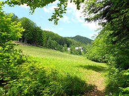
Leaving from Strumboding Waterfall in Hinterstoder, hike around the Steyrsberg! Cross the main country road at the Strumboding - Waterfall parking area and take trail nr. 9 through sparse high forests leading up to a forest road and further to a junction. Turn left (out of the valley) on nr. 46 to reach the Tambergau, turn right uphills through high forests to get to Schönau, a small plateau with a thick young forest situated between the Poppenberg and Steyrsberg mountains. At the end of a flat part the forest road forks ogain. Turn right and follow the road on nr. 26 to get to the Poppenberg, downhills half right along the foot path nr. 35 to Schmiedleiten and finally to the Vorderstoder – country road. Continue left on nr. 9/35 along a country path, pass the Stensberghof, on to the Lugis farm. Continue north via country path nr. 44 pass the Friedlbauer farm, continue downhills until you get to a forest road, forking a bit further down close to a beam. Turn down right to the beam to get to Hofbauer, keep left slightly upghills on nr. 46 leading into the valley along a forest road to get back to your starting point.
Trail-Nr: 46, 44, 35, 34
Trail-Nr: 46, 44, 35, 34
Starting point: Parking Strumboding Hinterstoder
Destination: Parking Strumboding Hinterstoder
Accessibility / arrival
The starting point is the car park at the Strumboding waterfall.
Most economical season
- Spring
- Summer
- Autumn
Please get in touch for more information.

Hinterstoder 38
4573 Hinterstoder
Phone +43 7564 5263 - 99
Fax machine +43 7564 5263 - 30
E-Mail hinterstoder@pyhrn-priel.net
Web www.urlaubsregion-pyhrn-priel.at
http://www.urlaubsregion-pyhrn-priel.at
Interactive elevation profile
Create PDF
Tour-Details
Path number: 9,46,44
Starting place: 4573 Hinterstoder
Destination: 4573 Hinterstoder
duration: 2h 52m
length: 5,8 km
Altitude difference (uphill): 475m
Altitude difference (downhill): 478m
Lowest point: 537m
Highest point: 821m
difficulty: easy
condition: easy
panoramic view: Some Views
Paths covering:
Gravel, Hiking trail
powered by TOURDATA