

Flötzersteig Tour (Circular Hiking World Hinterstoder)


- culturally interesting
Interactive elevation profile
Create PDF
Tour-Details
Paths covering:
Many sections of the Flötzersteig trail still lead along the original paths used by the Flötzer, created with an astonishing degree of effort, skill and courage.
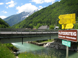
On the banks of the River Steyr, across from Gasthof Steyrbrücke, directly next to the bridge for the B 138 highway, we will set out on our hike along the Flötzersteig. This trailhead is also easy to reach from the railway station in Hinterstoder.
The Flötzersteig leads under the bridge, along the right bank of the Steyr and along the slopes of the Tamberg.
A gigantic rock in the middle of the river, shortly before the Sperrhäusl, draws our attention, and you can still make out the anchor points for the so-called Sperrrechen. Essentially a kind of weir which was once used as a collection point for tree trunks that had been floated downstream. Once they had been collected, the weir was reopened and the wood allowed to continue its journey down the river.
At the Sperrhäusl, the Flötzersteig now takes us up a few steps, after which we continue on a flat walk to the Pechhäusl (where pitch used to be burned). Immediately after the Pechhäusl comes a small ditch with occasional pools of water. Now we march along at a pleasant pace down the shady cart path, past the Godnhäusl by the Reschen, Reschen and, after a short climb, downhill to the main road.
All the while, we are treated time and again to many impressive views of the northern and eastern slopes of the Kleiner Priel (2,136 m).
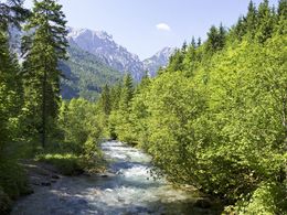
After the Flötzersteig has crossed Schrattental bridge, we immediately continue to the left on a gravel road and enjoy a shady walk alongside the Steyr.
Now amid riparian countryside adjacent to the Steyr, the Flötzersteig soon passes the Eistererhütt'n and Mundlhaus, and in just a few minutes we come to the Stampfsteg bridge, with the fairy-tale station featuring the Stodertal dwarves on the other side of the river (where the kids can actually make a crayon rubbing of the dwarves to take home with them as a special souvenir) . Now the path climbs briefly up to the Karlbauernanger. Here you can clearly recognize the deforestation caused by storms "Kyrill" in January 07 and "Paula" in January 08. At the end of this deforested area, the path leads uphill until we reach the Karlbauernweg.
We now continue left alongside the lush meadows of the Karlbauerngut, through a small village and, before we know it, the Flötzersteig has brought us to our pleasant refreshment stop at the Schnablgut. It is definitely worth taking a break in the Flötzerstub'n, where we will be able to sample their many homemade specialties.
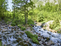
Shortly afterwards at the next farm, the Gütlergut, we turn right towards the forest’s edge. Past the Dörrhütte and then on the forestry road which runs along the side of the Kleiner Priel. After a meadow, the Flötzersteig leads us back down to the banks of the Steyr, and we soon hear the thunderous rumble of Stromboding waterfall.
Across the bridge, then briefly uphill, past walls of conglomerate rock to the “classic photo op” along the Flötzersteig, Stromboding waterfall.
There follows a short, very steep climb and, now above the waterfall, we come again to a bridge. It is worth pausing here for a little. You see the immense power of the water that has “broken” through the rocks here for millennia. You also gain a good sense of what a key hurdle this was for the Flötzer and how many must have lost their lives here.
Now the Flötzersteig climbs gently and we soon reach the path leading to Kreidehöhle cave (definitely worth a short detour), then past the fairy-tale station.
Now we cross a short, paved stretch – the Schwarzbach. This is the shortest stream in Stodertal valley at just two meters (can be nicely seen from the bank of the Steyr).But after powerful thunderstorms, this stream will rise and turn into a torrential river, which immediately submerges the Flötzersteig under water.
This spectacle is best photographed from the Stodertal waste-treatment plant on the opposite side. This plant is installed in the Poppenberg in two pipes.
Now the Flötzersteig soon reaches the Stodertal valley floor. Past Pension Prielkreuz, shortly afterwards a former mill, and we soon reach the Kneipp facility with the barefoot “Stoderzeit Organ Clock”. Now it is just a few minutes until we get to Hinterstoder.
The Alpineum is really a rewarding stopping point, impressively presenting to everyone the history of the Stodertal, including the life of the Flötzer and woodcutters, the birth of the sport of skiing, as well as the drama of the mountains themselves.
Now back on the Flötzersteig, we continue with a leisurely walk across riparian meadows to a true natural jewel, Schiederweiher tarn, the most photographed motif in Stodertal.
Time and again, we are treated to memorable views of the Spitzmauer and the Grosser Priel, before continuing through the Klinserau, in the direction of Dieltkapelle chapel. The Flötzersteig constantly offers sensational views of the mighty mountain backdrop that is the Totes Gebirge, which almost encircles us. Past the Dietlgut, across the Orchtwiese, with the cliffs of the Scheiblingstein on our right-hand side, we soon come to Gaststätte Baumschlagerreith.
From here it is only a few more minutes to the impressive headwaters of the River Steyr. The Steyr arises from many hundreds of holes, turning into a substantial small river within just a few meters.
Sit down, dangle your feet in the refreshing water, and enjoy the true achievement of having completed your hike along the Flötzersteig trail........
further information:
- Board possible
Details - hiking
- themed path
")

A9 motorway - exit St. Pankraz - right and then immediately left the station
Parking feesFor all those arriving by their own car, the cable car parking area is available at the entrance to our village. These parking areas can be used free of charge. During the hiking season, the Hinterstoder valley bus starts from here and connects the village with the hiking areas in the Polsterlucke, Dietlgut and up to the Baumschlagerreith at regular intervals. Paid parking from the village centre into the valley Our guests have three parking spaces at their disposal from the village centre towards the valley, which are located at the entry points to the network of hiking trails or to the Hinterstoder Hiking World and are equipped with information points on the hiking offers. The use of these three car parks is subject to a charge.
- Spring
- Summer
- Autumn
Please get in touch for more information.

Hinterstoder 38
4573 Hinterstoder
Phone +43 7564 5263
Fax machine +43 7564 5263 - 30
E-Mail hinterstoder@pyhrn-priel.net
Web www.urlaubsregion-pyhrn-priel.at
Interactive elevation profile
Create PDF
Tour-Details
Paths covering: