

Spaziergang zum Almsee


- Suitable for kids (all ages)
- Flatly
Interactive elevation profile
Create PDF
Tour-Details
Starting place: 4645 Grünau im Almtal
Destination: 4645 Grünau im Almtal
duration: 1h 37m
length: 5,2 km
Altitude difference (uphill): 177m
Altitude difference (downhill): 162m
Lowest point: 575m
Highest point: 646m
difficulty: very easy
condition: very easy
panoramic view: Some Views
Paths covering:
Hiking trail
powered by TOURDATA
Easy hike on problem-free paths.
Route description:
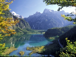
The Alm River has its source in a crystal-clear lake, directly beneath the northern walls of the Totes Gebirge. On its eastern shore, you hike through alluvial forests and reed bays, past brittle rock faces and springs that emerge below the lake level - rising air bubbles give them away.
At Gasthof Jagersimmerl, follow the signs for Almtaler Haus over the alpine bridge. Immediately afterwards, a forest road (no. 404) branches off to the right and leads through the hilly forest area next to the river into the valley. Soon you continue on a hiking trail, ascending slightly below the Brandberg and after a short descent you reach the Seeklause at Jagdhaus Schwarzenbrunn (bus stop). Now we walk along the Almsee, which is still narrow here. After 1 km, the water surface widens; the entire north face of the Totes Gebirge lies before us. Pass the fisherman's hut and enter the alluvial forest on the southern shore, then turn right over two footbridges to the Seehaus. Return via the same route (or by bus).
Hetzau & Ödseen lakes
A 6 km long road leads from Jagersimmerl to the Almtalerhaus, which can be used from early summer until the start of the hunting season in mid-September. A rewarding circular hike leads from the shelter to the two Ödseen lakes (1.5 hours). Above the head of the Hetzau valley stands the Schermberg north face, which at 1300 metres is one of the largest rock faces in the Alps. To the right of it, a gigantic landslide occurred at the end of the last ice age (around 15,000 years ago): the masses of debris thundered out over 12 kilometres through the valley and also dammed up the Almsee.
Rest stops:
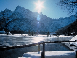
Gasthof Seehaus and Gasthof Deutsches Haus on the Almsee.
Route description:
The Alm River has its source in a crystal-clear lake, directly beneath the northern walls of the Totes Gebirge. On its eastern shore, you hike through alluvial forests and reed bays, past brittle rock faces and springs that emerge below the lake level - rising air bubbles give them away.
At Gasthof Jagersimmerl, follow the signs for Almtaler Haus over the alpine bridge. Immediately afterwards, a forest road (no. 404) branches off to the right and leads through the hilly forest area next to the river into the valley. Soon you continue on a hiking trail, ascending slightly below the Brandberg and after a short descent you reach the Seeklause at Jagdhaus Schwarzenbrunn (bus stop). Now we walk along the Almsee, which is still narrow here. After 1 km, the water surface widens; the entire north face of the Totes Gebirge lies before us. Pass the fisherman's hut and enter the alluvial forest on the southern shore, then turn right over two footbridges to the Seehaus. Return via the same route (or by bus).
Hetzau & Ödseen lakes
A 6 km long road leads from Jagersimmerl to the Almtalerhaus, which can be used from early summer until the start of the hunting season in mid-September. A rewarding circular hike leads from the shelter to the two Ödseen lakes (1.5 hours). Above the head of the Hetzau valley stands the Schermberg north face, which at 1300 metres is one of the largest rock faces in the Alps. To the right of it, a gigantic landslide occurred at the end of the last ice age (around 15,000 years ago): the masses of debris thundered out over 12 kilometres through the valley and also dammed up the Almsee.
Rest stops:
Gasthof Seehaus and Gasthof Deutsches Haus on the Almsee.
- Suitable for kids (all ages)
- Suitable for single travelers
- Spring
- Summer
- Autumn
- Early winter
Please get in touch for more information.
Im Dorf 17
4645 Grünau im Almtal
Phone +43 7616 8268
E-Mail almtal@traunsee-almtal.at
Web www.traunsee-almtal.at
Web www.gruenau.ooe.gv.at/
http://www.traunsee-almtal.at
http://www.gruenau.ooe.gv.at/
http://www.gruenau.ooe.gv.at/
")
")
")
")
Interactive elevation profile
Create PDF
Tour-Details
Starting place: 4645 Grünau im Almtal
Destination: 4645 Grünau im Almtal
duration: 1h 37m
length: 5,2 km
Altitude difference (uphill): 177m
Altitude difference (downhill): 162m
Lowest point: 575m
Highest point: 646m
difficulty: very easy
condition: very easy
panoramic view: Some Views
Paths covering:
Hiking trail
powered by TOURDATA