

Eckhartrunde - "The Weatherproof"


- All weather
- Suitable for families
- Suitable for pushchairs
- Flatly
Interactive elevation profile
Create PDF
Tour-Details
Starting place: 4574 Vorderstoder
Destination: 4574 Vorderstoder
duration: 1h 15m
length: 4,3 km
Altitude difference (uphill): 119m
Altitude difference (downhill): 118m
Lowest point: 743m
Highest point: 815m
difficulty: easy
condition: easy
panoramic view: Great panorama
Paths covering:
Asphalt, Gravel, Other
powered by TOURDATA
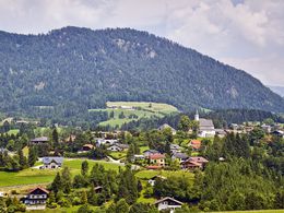
If you like to be out and about in all weathers, the Eckhartrunde offers the right conditions. Experience the change of seasons and see Vorderstoder from a different perspective around the Schafferkogel.
Start in the village centre and walk along the main road in the direction of Windischgarsten. After passing the fire station, you will reach the "Käserei" bus stop. Turn right there and follow the road uphill until you reach the Schaffergut on the right. At the fork in the road, keep to the right and continue to follow the road that leads behind the Schafferkogel.
You cross the settlement and pass the Edtbauer horse stud farm and the Eckhart farm. Enjoy the view of gentle meadows, the Schafferkogel and the Tamberg on the opposite side of the valley.
In good weather, the view sweeps towards Hinterstoder over numerous peaks of the dead mountains. In front are the Kleine and Große Priel, next to it the striking silhouette of the Spitzmauer and in front of it the Ostrawitz.
At the next junction, turn right and march downhill with a view of Vorderstoder.
On the right, you will reach the Stodertal forest and water playground "Swuwiz" via a small bridge, which invites you to play and discover. Through the forest you get back uphill to the country road, which you follow further uphill. After a few minutes you will reach your original starting point.
Starting point: Municipal office Vorderstoder
Destination: Municipal office Vorderstoder
further information:
- Flatly
- Board possible
Details - hiking
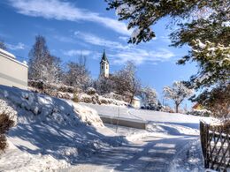
- cleared winter hiking path
Accessibility / arrival
Start and finish is directly at the info point next to the municipal office in Vorderstoder.
(47.712691, 14.224847)
Parking is available in the signposted car parks in the immediate vicinity.
The nearest bus stop is called "Gh Steinerweirt" and is a minute's walk away.
- Charging point for electric cars (fees apply)
- All weather
- Suitable for groups
- Suitable for schools
- Suitable for pushchairs
- Suitable for teenagers
- Suitable for seniors
- Suitable for single travelers
- Suitable for friends
- Suitable for couples
- Suitable for children
- Spring
- Summer
- Autumn
- Early winter
Please get in touch for more information.

Nr. 66
4574 Vorderstoder
Phone +43 7564 8255
Fax machine +43 7564 8255 - 20
E-Mail vorderstoder@pyhrn-priel.net
Web www.urlaubsregion-pyhrn-priel.at
https://www.urlaubsregion-pyhrn-priel.at
")
")
Interactive elevation profile
Create PDF
Tour-Details
Starting place: 4574 Vorderstoder
Destination: 4574 Vorderstoder
duration: 1h 15m
length: 4,3 km
Altitude difference (uphill): 119m
Altitude difference (downhill): 118m
Lowest point: 743m
Highest point: 815m
difficulty: easy
condition: easy
panoramic view: Great panorama
Paths covering:
Asphalt, Gravel, Other
powered by TOURDATA