

Sonnwend-Gunst


- pets allowed
- Suitable for families
- Flatly
- Possible accommodation
Interactive elevation profile
Create PDF
Tour-Details
Starting place: 4580 Windischgarsten
Destination: 4580 Windischgarsten
duration: 1h 18m
length: 5,0 km
Altitude difference (uphill): 77m
Altitude difference (downhill): 78m
Lowest point: 598m
Highest point: 667m
difficulty: easy
condition: easy
panoramic view: Great panorama
Paths covering:
Asphalt, Hiking trail
powered by TOURDATA
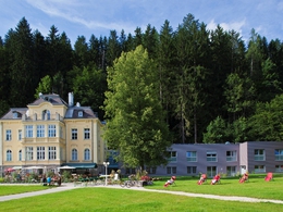
Hike from Windischgarsten past the Sonnwendkogel and Gunst to Villa Sonnwend and back again! A street leads past the retirement home to the Kalvarienberg. You will hike along the Salzabach down into the valley, and you will be able to see the beautiful lane lined by chestnut trees, which leads to Villa Sonnwend National Park Lodge, where you can stop for refreshments. In front of the entrance to Villa Sonnwend, the path leads right across a meadow and past the landing field for hang- and paragliders. You will cross a small village, and then the path leads steeply uphill. Now, you will go downhill along a lane lined by fruit trees and can enjoy a view of the valley. From here, you can already see the Kalvarienberg and will return to the starting point.
Starting point: Windischgarsten tourist office
Destination: Windischgarsten tourist office
further information:
- Flatly
- Possible accommodation
Details - hiking
- cleared winter hiking path
Accessibility / arrival
From the north on the A9 direction Graz - exit Roßleithen,
from the south on the A9 direction Linz departure Roßleithen.
Pyhrnbahn (Linz - Graz) stop Windischgarsten
Airports: Linz / Hörsching, Vienna, Salzburg, Graz
- Suitable for groups
- Suitable for schools
- Pets allowed
- Spring
- Summer
- Autumn
- Early winter
- Deep winter
Please get in touch for more information.

Hauptstraße 28
4575 Roßleithen
Phone +43 7562 5266 - 99
Fax machine +43 7562 5266 - 10
E-Mail info@pyhrn-priel.net
Web www.urlaubsregion-pyhrn-priel.at
http://www.urlaubsregion-pyhrn-priel.at
Interactive elevation profile
Create PDF
Tour-Details
Starting place: 4580 Windischgarsten
Destination: 4580 Windischgarsten
duration: 1h 18m
length: 5,0 km
Altitude difference (uphill): 77m
Altitude difference (downhill): 78m
Lowest point: 598m
Highest point: 667m
difficulty: easy
condition: easy
panoramic view: Great panorama
Paths covering:
Asphalt, Hiking trail
powered by TOURDATA