

Hasenberg tour


- pets allowed
- Suitable for families
- Suitable for pushchairs
- Flatly
Interactive elevation profile
Create PDF
Tour-Details
Starting place: 4582 Spital am Pyhrn
Destination: 4582 Spital am Pyhrn
duration: 1h 3m
length: 3,5 km
Altitude difference (uphill): 100m
Altitude difference (downhill): 95m
Lowest point: 655m
Highest point: 738m
difficulty: easy
condition: easy
panoramic view: Great panorama
Paths covering:
Asphalt, Gravel
powered by TOURDATA
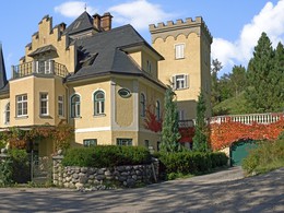
The Hasenberg tour will lead you via the Grünau to the Sonnenhang and back! From the car park of the Panorama indoor pool in Spital am Pyhrn, walk along the road to the Grünau district. In Grünau, turn sharp left before the Bosruckhütte goods road and follow the path until you come to tarmac again. Walk past the large yellow villa on the left until you reach the houses. Walk along the houses on the left down the road to the railway bridge. After the bridge, turn right along the railway. At the end, go left through the settlement and back to the starting point.
Starting point: car park at the Panorama Indoor Pool in Spital am Pyhrn!
Destination: car park at the Panorama Indoor Pool in Spital am Pyhrn!
further information:
- Flatly
Details - hiking
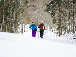
- cleared winter hiking path
")

")
")
Accessibility / arrival
car park at the Panorama Indoor Pool in Spital am Pyhrn
- Suitable for groups
- Suitable for schools
- Suitable for pushchairs
- Pets allowed
- Spring
- Summer
- Autumn
- Early winter
- Deep winter
Please get in touch for more information.

Stiftsplatz 1
4582 Spital am Pyhrn
Phone +43 7563 249
E-Mail spital@pyhrn-priel.net
Web www.urlaubsregion-pyhrn-priel.at
https://www.urlaubsregion-pyhrn-priel.at
")
")
")
")
Interactive elevation profile
Create PDF
Tour-Details
Starting place: 4582 Spital am Pyhrn
Destination: 4582 Spital am Pyhrn
duration: 1h 3m
length: 3,5 km
Altitude difference (uphill): 100m
Altitude difference (downhill): 95m
Lowest point: 655m
Highest point: 738m
difficulty: easy
condition: easy
panoramic view: Great panorama
Paths covering:
Asphalt, Gravel
powered by TOURDATA