

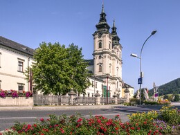
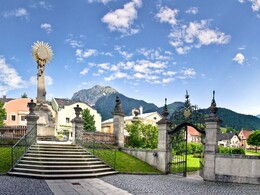
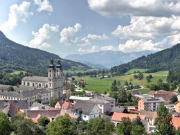
Processional Path in Spital am Pyhrn


- Flatly
Interactive elevation profile
Create PDF
Tour-Details
Starting place: 4582 Spital am Pyhrn
Destination: 4582 Spital am Pyhrn
duration: 0h 19m
length: 1,4 km
Lowest point: 635m
Highest point: 640m
difficulty: very easy
condition: very easy
panoramic view: Individual Views
Paths covering:
Asphalt, Gravel
powered by TOURDATA
A short, leisurely stroll in the centre of Spital am Pyhrn
From the town square in Spital am Pyhrn, walk to the savings bank and past the monastery outbuilding on the right. Behind it is the beautiful monastery pond of Spital am Pyhrn. This is also where Anzwiesenallee begins, which you follow to the end. Now turn right over the Teichlbrücke bridge and right again, following Austraße, back to Dom am Pyhrn, the starting point.
From the town square in Spital am Pyhrn, walk to the savings bank and past the monastery outbuilding on the right. Behind it is the beautiful monastery pond of Spital am Pyhrn. This is also where Anzwiesenallee begins, which you follow to the end. Now turn right over the Teichlbrücke bridge and right again, following Austraße, back to Dom am Pyhrn, the starting point.
Starting point: Spital am Pyhrn town square
Destination: Spital am Pyhrn town square
further information:
- Flatly
- Board possible
Details - hiking
- cleared winter hiking path

")
Accessibility / arrival
town center of Spital am Pyhrn
E-service station / recharging station- Charging point for electric cars (free of charge)
- Charging point for e-bikes (free of charge)
Most economical season
- Spring
- Summer
- Autumn
- Early winter
- Deep winter
Please get in touch for more information.

Stiftsplatz 7
4582 Spital am Pyhrn
Phone +43 7563 249 - 99
Fax machine +43 7563 249 - 20
E-Mail spital@pyhrn-priel.net
Web www.urlaubsregion-pyhrn-priel.at
http://www.urlaubsregion-pyhrn-priel.at
")
")
")

Interactive elevation profile
Create PDF
Tour-Details
Starting place: 4582 Spital am Pyhrn
Destination: 4582 Spital am Pyhrn
duration: 0h 19m
length: 1,4 km
Lowest point: 635m
Highest point: 640m
difficulty: very easy
condition: very easy
panoramic view: Individual Views
Paths covering:
Asphalt, Gravel
powered by TOURDATA