

Prielkreuz Loop


- pets allowed
- Suitable for families
- Flatly
Interactive elevation profile
Create PDF
Tour-Details
Starting place: 4573 Hinterstoder
Destination: 4573 Hinterstoder
duration: 1h 0m
length: 3,1 km
Altitude difference (uphill): 76m
Altitude difference (downhill): 75m
Lowest point: 576m
Highest point: 614m
difficulty: very easy
condition: very easy
panoramic view: Some Views
Paths covering:
Asphalt, Gravel
powered by TOURDATA
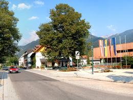
The Prielkreuz tour leads from the town center of Hinterstoder to the outskirts of town at the gas station, and on the far side of the Steyr river back into the town center. Village hall/tourist office – along the main road in the direction of the bridge over the Steyr – at the toll-road turn-off, take the footpath towards the Poppenberg as far as the IQ petrol station – briefly hike towards the mouth of the valley, then left across the bridge (Schachinger Steg) past former Pension Prielkreuz – after the mill/Kneipp facility, either follow the left bank of the Steyr back to Hinterstoder, or make a left and take a narrow trail (next to the Lafthütte), heading upriver through a riparian meadow back to the town center.
Starting point: tourist office in Hinterstoder
Destination: tourist office in Hinterstoder
further information:
- Flatly
- Board possible
Details - hiking
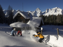
- cleared winter hiking path
Accessibility / arrival
From Vienna: West motorway direction Salzburg - A1 junction Voralpenkreuz - A9, exit Hinterstoder / St. Pankraz - Hinterstoder
From Munich: A8 Salzburg - West motorway A1 direction Linz - turn Voralpenkreuz - A9, exit Hinterstoder / St. Pankraz - Hinterstoder
From Berlin: A9 Bayreuth - Nuremberg - A3 Regensburg - Passau - A8 to junction Voralpenkreuz - A9, exit Inzersdorf - Kirchdorf / Krems - Hinterstoder
Vienna - Linz - Hinterstoder;
Munich - Salzburg - Linz - Hinterstoder;
Hamburg - Passau - Linz - Hinterstoder;
Frankfurt - Passau - Linz - Hinterstoder;
Berlin - Nürnberg - Passau - Linz - Hinterstoder;
Airports: Linz / Hörsching, Vienna, Salzburg
- Suitable for groups
- Suitable for schools
- Pets allowed
- Spring
- Summer
- Autumn
- Early winter
- Deep winter
Please get in touch for more information.
Hinterstoder 38
4573 Hinterstoder
Phone +43 7564 5263 - 99
Fax machine +43 7564 5263 - 30
E-Mail hinterstoder@pyhrn-priel.net
Web www.urlaubsregion-pyhrn-priel.at
http://www.urlaubsregion-pyhrn-priel.at
Interactive elevation profile
Create PDF
Tour-Details
Starting place: 4573 Hinterstoder
Destination: 4573 Hinterstoder
duration: 1h 0m
length: 3,1 km
Altitude difference (uphill): 76m
Altitude difference (downhill): 75m
Lowest point: 576m
Highest point: 614m
difficulty: very easy
condition: very easy
panoramic view: Some Views
Paths covering:
Asphalt, Gravel
powered by TOURDATA