

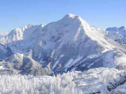
Ski tour Gr. Pyhrgasgrat (touring area Hallermauern)


Interactive elevation profile
Create PDF
Tour-Details
Starting place: 4582 Spital am Pyhrn
Destination: 4582 Spital am Pyhrn
duration: 4h 25m
length: 5,4 km
Altitude difference (uphill): 1.104m
Altitude difference (downhill): 87m
Lowest point: 884m
Highest point: 1.902m
difficulty: medium
condition: medium
panoramic view: Great panorama
Paths covering:
snow
powered by TOURDATA
The Gr. Pyhrgasgrat by the Holzerkar the direct ascent is usually by mid-May walkable, advisable only for mountaineers. From the car park follow the road very flat valley Gr. Pyhrgas to Holzeralm to around 1,120 m. Now go over the wide, flat pastureland first left back, then right very steeply over the first boom and continues until the Kar is reached. On Karan catch it's very flat valley to snack stone at around 1,700 m. Now you keep to the left, the distinctive snow gully climb where it finally very steep (ski depot) is. The last 50 vertical meters you walk in the nick.
Departure:
How ascent.
Departure:
How ascent.
Starting point: Parking Goslitz Oberweng
Destination: Parking Goslitz Oberweng
Details - Ski
- Descent: difficulty: medium, 1080 Metres of altitude
Accessibility / arrival
In Spital am Pyhrn, go up to Oberweng and follow the signs to Jausenstube Singerskogel. Once there, go a few hundred meters of the road to the parking lot.
Most economical season
- Spring
- Deep winter
Please get in touch for more information.
Stiftsplatz 1
4582 Spital am Pyhrn
Phone +43 7563 249
Fax machine +43 7563 249 - 20
E-Mail spital@pyhrn-priel.net
Web www.urlaubsregion-pyhrn-priel.at
http://www.urlaubsregion-pyhrn-priel.at
Interactive elevation profile
Create PDF
Tour-Details
Starting place: 4582 Spital am Pyhrn
Destination: 4582 Spital am Pyhrn
duration: 4h 25m
length: 5,4 km
Altitude difference (uphill): 1.104m
Altitude difference (downhill): 87m
Lowest point: 884m
Highest point: 1.902m
difficulty: medium
condition: medium
panoramic view: Great panorama
Paths covering:
snow
powered by TOURDATA