

Skitour on the Katrin


- culinary interesting
Interactive elevation profile
Create PDF
Tour-Details
Starting place: 4820 Bad Ischl
Destination: 4820 Bad Ischl
duration: 3h 27m
length: 3,6 km
Altitude difference (uphill): 910m
Lowest point: 479m
Highest point: 1.389m
difficulty: medium
condition: medium
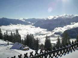
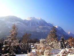
panoramic view: Great panorama
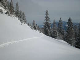
Paths covering:
snow
powered by TOURDATA
The former ski area is a very popular spot for ski mountaineers. The slope is 4km long and the difference in altitude is 900m. On the top of the mountain you can enjoy a fantastic view and boost yourself with traditional meals in the alpine cabin. You can either go by car, take the city bus (Mo-Fr) or a taxi to the valley station of the Katrin Cable Car, which is the point of departure. The tour starts on the former ski slope. After about one hour, you can choose if you stay on the slope or follow the forest road through the Windengraben. Both tracks are always laid. Though the tour is usually not affected by avalanches, you should always carry your avalanche rescue gear with you and know how to use it!
Starting point: valley station of the Katrin cablecar which is only open in summer
Destination: Katrinalm - alpine cabin
further information:
- culinary interesting
- Board possible
Details - Ski
- Descent: difficulty: medium, 1000 Metres of altitude
- enjoy a downhill on the former ski slope
Most economical season
- Spring
- Early winter
- Deep winter
Please get in touch for more information.
4820 Bad Ischl
Phone +43 6132 23788
E-Mail info@katrinseilbahn.com
Web www.katrinseilbahn.com
http://www.katrinseilbahn.com
Interactive elevation profile
Create PDF
Tour-Details
Starting place: 4820 Bad Ischl
Destination: 4820 Bad Ischl
duration: 3h 27m
length: 3,6 km
Altitude difference (uphill): 910m
Lowest point: 479m
Highest point: 1.389m
difficulty: medium
condition: medium
panoramic view: Great panorama
Paths covering:
snow
powered by TOURDATA