

Cross-country ski run in Tiefgraben - Mondsee
 TVB Mondsee - Irrsee")
 TVB Mondsee - Irrsee")
 TVB Mondsee - Irrsee")

- pets allowed
- All weather
- Suitable for families
Interactive elevation profile
Create PDF
Tour-Details
Starting place: 4893 Tiefgraben am Mondsee
Destination: 4893 Tiefgraben am Mondsee
duration: 2h 0m
length: 5,0 km
Altitude difference (uphill): 44m
Altitude difference (downhill): 20m
Lowest point: 527m
Highest point: 575m
difficulty: medium
condition: medium
panoramic view: Some Views
Paths covering:
snow, Other
powered by TOURDATA
Trail not in operation
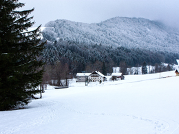
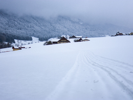
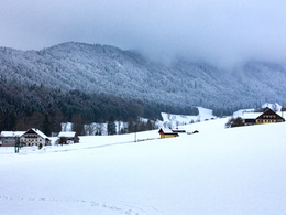
This scenic cross-country run leads from the ice sports hall in Mondsee to the lakefront of lake Irrsee.We start our tour from the parking lot at the ice sports hall in Mondsee westwards, where we reach an open field. To our left hand side lays the Erlachmühle, Mondsees oldest, still working mill. We follow the trail of the cross-country ski run until we reach a chapel at the streamside and cross a small bridge. The route now follows the stream at the left side, then again at the right side. We pass some big farms and reach the lakefront of lake Irrsee after about two hours.
Starting point: Ice rink Mondsee
Destination: Hotel Pöllmann at lake Irrsee
further information:
- Experience of nature
Details - Trail
- Nordic skiing facilities: Marked Nordic skiing run
- Type of Nordic skiing run: Classic style
- free
If snow conditions are sufficient
Accessibility / arrival
The cross-country ski run starts at the parking lot behind the Mondsee ice rink (soccer field). From here you start in a westerly direction (direction to lake Irrsee).
- Parking space: 100
none
General price information
free of charge.
- All weather
- Suitable for groups
- Pets allowed
- Suitable for teenagers
- Suitable for seniors
- Suitable for single travelers
- Suitable for friends
- Suitable for couples
Only passable when there is enough snow.
For information, please call the tourist office: +43 6232 2270.
- Deep winter
Please get in touch for more information.
Dr. Franz Müller Straße 3
4893 Tiefgraben am Mondsee
Phone +43 6232 2270
E-Mail info@mondsee.at
Web www.mondsee.at
https://www.mondsee.at
Interactive elevation profile
Create PDF
Tour-Details
Starting place: 4893 Tiefgraben am Mondsee
Destination: 4893 Tiefgraben am Mondsee
duration: 2h 0m
length: 5,0 km
Altitude difference (uphill): 44m
Altitude difference (downhill): 20m
Lowest point: 527m
Highest point: 575m
difficulty: medium
condition: medium
panoramic view: Some Views
Paths covering:
snow, Other
powered by TOURDATA