

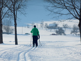
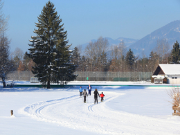
Lakeside cross-country ski trail


- All weather
- Suitable for families
- Suitable for kids (all ages)
- culinary interesting
- Flatly
- Possible accommodation
Interactive elevation profile
Create PDF
Tour-Details
Starting place: 5350 Strobl
Destination: 5350 Strobl
duration: 4h 30m
length: 18,4 km
Altitude difference (uphill): 56m
Altitude difference (downhill): 57m
Lowest point: 538m
Highest point: 559m
difficulty: easy
condition: easy
panoramic view: Great panorama
Paths covering:
snow
powered by TOURDATA
Trail not in operation
Die Seeufer Loipe am Wolfgangsee bietet 20 km gespurte Loipen in Klassischer Technik und Skating Technik an.Course of the trail:
From the sports field Strobl through the nature reserve "Blinklingmoos", along the lakeshore, crossing the country road to the village of Gschwendt (connection to the lakeshore cross-country ski trail St. Gilgen), continue to the inn Wiesenhof, continue via Zinkenbachsteg to Reith, past the Seehotel Huber, along the lakeshore to Farchen, continue to the inn Gamsjaga and in a curve across the fields back.
Starting point: Strobl sports field
Destination: Strobl sports field
further information:
- culinary interesting
- Flatly
- Possible accommodation
Details - Trail
- Nordic skiing facilities: Marked Nordic skiing run
- Type of Nordic skiing run: Classic + skating
- free
December till Feburary
Accessibility / arrival
Starting points:
Strobl sports field (P), Alpenmoorbad Hotel on the southern edge of Strobl or the Wiesenhof Guesthouse on the main road (P)
- Parking space: 20
General price information
free use of the cross country ski trail
- All weather
- Suitable for groups
- Suitable for schools
- Suitable for kids (all ages)
- Suitable for teenagers
- Suitable for seniors
- Suitable for single travelers
- Suitable for friends
- Suitable for couples
- Suitable for children
- Deep winter
Please get in touch for more information.
5350 Strobl
Phone +43 6137 7255
E-Mail info@wolfgangsee.at
Web www.wolfgangsee.at
http://www.wolfgangsee.at
Interactive elevation profile
Create PDF
Tour-Details
Starting place: 5350 Strobl
Destination: 5350 Strobl
duration: 4h 30m
length: 18,4 km
Altitude difference (uphill): 56m
Altitude difference (downhill): 57m
Lowest point: 538m
Highest point: 559m
difficulty: easy
condition: easy
panoramic view: Great panorama
Paths covering:
snow
powered by TOURDATA