

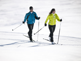
Golf course cross-country ski trail


- All weather
- Suitable for families
- Flatly
- Possible accommodation
Interactive elevation profile
Create PDF
Tour-Details
Starting place: 5360 St. Wolfgang im Salzkammergut
Destination: 5360 St. Wolfgang im Salzkammergut
duration: 1h 28m
length: 5,6 km
Altitude difference (uphill): 62m
Altitude difference (downhill): 58m
Lowest point: 505m
Highest point: 556m
difficulty: medium
condition: medium
panoramic view: Individual Views
Paths covering:
snow
powered by TOURDATA
Trail not in operation
The Golf course circular trail is 4 km long, in classic technique and skating technique. Trail route:Leaving the Golfhotel, go a short distance nortwards along the road, then westwards via Wirling to Radau where the trail splits. Going left, the trail is at first flat, followed by a lengthy uphill stretch to Windhag and then leads, by way of a long gentle descent, back to the Golfhotel.
Starting point: The Golfhotel in Aschau
Destination: The Golfhotel in Aschau
further information:
- Flatly
- Possible accommodation
Details - Trail
- Nordic skiing facilities: Marked Nordic skiing run
- Type of Nordic skiing run: Classic + skating
- free
December till February
Accessibility / arrival
Starting point:
The Golfhotel, reachable from the Wolfgangsee main road via a short connecting road.
- Parking space: 5
General price information
free of charge
- All weather
- Suitable for groups
- Suitable for schools
- Suitable for teenagers
- Suitable for seniors
- Suitable for single travelers
- Suitable for friends
- Deep winter
Please get in touch for more information.
Au 140
5360 St. Wolfgang im Salzkammergut
Phone +43 6138 8003
E-Mail info@wolfgangsee.at
Web www.wolfgangsee.at
http://www.wolfgangsee.at
Interactive elevation profile
Create PDF
Tour-Details
Starting place: 5360 St. Wolfgang im Salzkammergut
Destination: 5360 St. Wolfgang im Salzkammergut
duration: 1h 28m
length: 5,6 km
Altitude difference (uphill): 62m
Altitude difference (downhill): 58m
Lowest point: 505m
Highest point: 556m
difficulty: medium
condition: medium
panoramic view: Individual Views
Paths covering:
snow
powered by TOURDATA