

Bad Goisern - Attersee with the road bike variant II - long


Interactive elevation profile
Create PDF
Tour-Details
Paths covering:
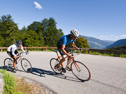
Cycling through the Salzkammergut and discovering the most beautiful lakes along the way
Started at Agathawirt Country Hotel in Bad Goisern at Lake Hallstatt (district of St. Agatha). On the federal highway B145 you drive to Bad Ischl. In Bad Ischl, turn north towards direction Ebensee / Gmunden. Before Ebensee, turn left to the Weißenbachtal (B153) to Weissenbach at Lake Attersee. The route takes you to Steinbach and Weyregg. Past Schörfling, Seewalchen, Attersee and Nussdorf you drive through Unterach and then further to Lake Mondsee.
As like the short distance you past Wiesenau, Schafling, St. Gilgen and Strobl, before you cycle back to the starting point at the Agathawirt Country Hotel in Bad Goisern at Lake Hallstatt.
Experience a 360° Panorama Tour through the Dachstein Salzkammergut region
by car
from Salzburg:
Exit Thalgau via federal road B158 towards Bad Ischl, in Bad Ischl drive onto Salzkammergut Street B145 towards Bad Goisern, continuing to St. Agatha
from Linz:
Exit Regau via federal road Salzkammergut street B145 towards Gmunden and Bad Ischl to Bad Goisern, continuing to St. Agatha
from Vienna/Graz:
Exit Liezen via federal road B320, in Trautenfels drive onto Salzkammergut street B145 towards Bad Goisern, in the district of St. Agatha
from Villach:
Tauern motorway to exit "Eben im Pongau", via B166 Pass Gschütt federal road through Gosau, at the Gosaumühle junction turn towards Bad Goisern, turn right in the direction of St. Agatha
by train
Attnang-Puchheim - Stainach-Irdning lines
stop "Steeg / Gosau", from there about 1.9 km away
by bus
Bus 542 (Bad Ischl - Gosausee)
stop St. Agatha Agathawirt
Detailed information on the respective train and bus times can be found at https://www.oebb.at/en/ (train) and https://www.postbus.at/en (bus).
- Parking space: 20
- Bus parking space: 1
for free
- Suitable for groups
- Suitable for single travelers
- Suitable for friends
- Suitable for couples
- Spring
- Summer
- Autumn
Please get in touch for more information.

4822 Bad Goisern am Hallstättersee
Phone +43 5 95095 - 10
Fax machine +43 5 95095 - 74
E-Mail goisern@dachstein-salzkammergut.at
Web www.dachstein-salzkammergut.at
You can also visit us on
Visit us on Facebook Visit us on Instagram Visit us on Pinterest Visit our videochannel on YouTube WikipediaInteractive elevation profile
Create PDF
Tour-Details
Paths covering: