

Salzkammergut Trophy gravel bike training course C


Interactive elevation profile
Create PDF
Tour-Details
Paths covering:
Lake Gosau, Lake Hallstatt, beautiful alpine pastures, majestic glaciers,... this gravel bike route is full of highlights!
The highlight of the Salzkammergut Trophy gravel bike training course C
The Salzkammergut Trophy gravel bike training course is not only a physical adventure but also a scenic dream. Here you get the full load of Dachstein Salzkammergut. With the Lake Hallstatt, Hallstatt, the Waldbachstrub waterfalls, Gosau's mountain pastures and Lake Gosau including Dachstein it is the highlight tour par excellence in the Inner Salzkammergut.
The gravel bike route
In contrast to the race, the start on the training course is not in Obertraun but in Bad Goisern at Lake Hallstatt. From the parking "Mitte", you first go through the village to the Goisern South exit. Here is a bicycle path or the road that will take you to the Landgasthof "Zur Post". Here the route continues below the Arikogel to Untersee, where it is not far to the Lake Hallstatt.
On the R2, the esat bank bike trail, we finally cycle along the Lake Hallstatt directly to Obertraun. We briefly ride on a spectacular suspension bridge over the deepest part of Lake Hallstatt before we get our first glimpse of the World Heritage site Hallstatt. The path continues to Obertraun until we reach the beach resort. An ideal bathing place during a summer tour. After the beach resort you pass the official starting point of the gravel bike competition of the Salzkammergut Trophy.
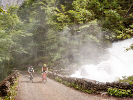
Then it goes in the direction of Hallstatt. Here the gravel biker can save themselves the steep ascent to the Salzberg and also on the training course it goes directly into the Echerntal. Now there are about 1 000 meters of ascent in front of you. Up on an asphalt road through the Echern, past the Waldbachstrub, admiring the rugged mountain Plassen, to the highest point of the tour - the "Durchgang Alm".
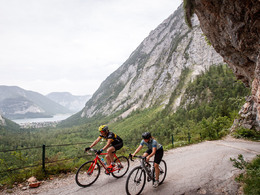
After a relatively short driving time you reach the mountain pasture Rossalm, an ideal stop to replenish your reserves before a long descent to one of the most beautiful places of the Salzkammergut begins. Shortly past the "Löckenmoos" (Place of Happiness) you pass the Ebenalm and then it lies in front of you: the Lake Gosau with its majestic Dachstein glacier! There must be time for a short photo!
After a short breather from the long and demanding descent, the gravel route leads along the Lake Gosau road to the sawmill and a small bridge. There we continue on the trail next to the "Gosaubach", away from the traffic. You will pass the valley station of the Hornspitz lift before you pass the rural part of Gosau at Dachstein. A mountain pasture in the village, one would almost think, many sheep, cows and horses line the way here. You continue through the so-called fairytale forest until you reach the fishpond Gosau.
Now the asphalt is calling! On the national road it goes down now up to the "Gosauzwang" crossing, the border between Bad Goisern/Gosau/Hallstatt. On the left the national road leads to Bad Goisern. Here you drive again briefly along the Lake Hallstatt before you return to the Bad Goisern South entrance and finally to the starting point.
Here you will find more important information about gravel biking.
Experience the 360 degree live panorama of Bad Goisern....
The gravel bike tour starts at the parking "Mitte" in Bad Goisern at Lake Hallstatt.
by car
from Salzburg:
Exit Thalgau via federal road B158 towards Bad Ischl, in Bad Ischl drive onto Salzkammergut Street B145 towards Bad Goisern
from Linz:
Exit Regau via federal road Salzkammergut street B145 towards Gmunden and Bad Ischl to Bad Goisern
from Vienna/Graz:
Exit Liezen via federal road B320, in Trautenfels drive onto Salzkammergut street B145 towards Bad Goisern
from Villach:
Tauern motorway to exit "Eben im Pongau", via B166 Pass Gschütt federal road through Gosau, at the Gosaumühle junction turn towards Bad Goisern
by train
Attnang-Puchheim - Stainach-Irdning lines
stop train station Bad Goisern, from there about 400 m away
by bus
Bus 542 (Bad Ischl - Gosausee)
stop Bad Goisern Mitte/B145
Detailed information on the respective train and bus times can be found at https://www.oebb.at/en/ (train) and https://www.postbus.at/en (bus).
- Parking space: 50
- Parking area for disabled: 2
- Bus parking space: 5
for free
- Suitable for groups
- Suitable for single travelers
- Suitable for friends
- Suitable for couples
- Spring
- Summer
- Autumn
Please get in touch for more information.
Kirchengasse 4
4822 Bad Goisern am Hallstättersee
Phone +43 5 95095 - 10
E-Mail goisern@dachstein-salzkammergut.at
Web dachstein.salzkammergut.at
You can also visit us on
Visit us on Facebook Visit us on Instagram Visit us on Pinterest Visit our videochannel on YouTube WikipediaInteractive elevation profile
Create PDF
Tour-Details
Paths covering: