

2-day tour "Around the Attersee" - Second stage: Seefeld-Abtsdorf


- All weather
Interactive elevation profile
Create PDF
Tour-Details
Starting place: 4853 Steinbach am Attersee
Destination: 4864 Attersee am Attersee
duration: 5h 49m
length: 62,8 km
Altitude difference (uphill): 1.910m
Altitude difference (downhill): 1.874m
Lowest point: 469m
Highest point: 1.041m
difficulty: difficult
condition: difficult
panoramic view: Great panorama
Paths covering:
Asphalt, Gravel, Street, Other
powered by TOURDATA
Starting height: 484 m | Highest point: 1006 m | Lowest point: 467 m | Height: 1.471 m | Total distance: 63.4 km | Travel time: 6 hours
Roadbook: Seefeld – Abtsdorf
Refreshment stops:
Gastronomy options in Seefeld or in Steinbach am Attersee
On the route:
2 mountain huts in the Eisenaueralm, restaurants in Unterach, Seegasthof Stadler, restaurants in Oberwang, and restaurants in Nußdorf am Attersee.
Destination: Gastronomic establishments in Abtsdorf, 4 Gasthofs within 400m.
Particularities:
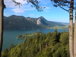
Many different views of Attersee and Mondsee. View of the Schafberg, the Höllengebirge.
Swimming.
Roadbook: Seefeld – Abtsdorf
- 0,0 km starting point Seefeld, parking next to Bierschmiede, direction to the lake and left on the main road, further along the Attersee.
- 7,5 km In Burgau, at the Eitzinger campsite, turn left into the Forest road (before Holzhütte) in the direction to Eisenau
- 12,0 km Leave Holzhütte on the left and turn right at the fork in the direction Eisenau / Unterach (additional information: MTB-route MB11)
- 12.4 km towards Buchberghütte / Eisenauer Alm
- 14.3 km At the crossroad turn right towards Eisenau (additional information: RW11)
- 16.8 km At the crossroad turn right to Buchenberghütte (stop) or turn left to go directly
- 17.9 km At the crossroads to the left (additional information: MB11)
- 23.3 km At the end of the forest road (after the barrier) turn right onto the main road in the direction to Unterach (additional information: RW3)
- 23.8 km At the crossroads turn right in the direction to Unterach, after approx. 500 m in the tunnel use the tube for cyclists, ATTENTION: Road must be crossed
- 28.3 km After the bridge turn right onto the cycle path next to the main road (additional information: RW3)
- 29.6 km Turn right towards Mühlleiten (additional information: RW3)
- 30.5 km In Mühlleiten under the bridge through and straight ahead continue in the direction to the center of the village Unterach
- 33.0 km Turn right onto the main road (additional information: R2) and follow this road
- 35.0 km In Misling, turn left from the main road and follow the Salzkammergut cycle path (additional information: R2, Magarethengut)
- 35.2 km Turn right and continue along the cycle path (additional information: R2)
- 35.6 km Continue along the Salzkammergut cycle path (additional information: R2)
- 36.6 km turn left towards Aichereben (additional information: Westwanderweg, Eglsee, Reiserbauernmühle)
- 37.6 km Straight ahead towards Nußdorf
- 40.3 km After the first part of the exit from Aichereben turn left at the intersection in the forest in the direction to Oberwang
- 41.9 km In Riedlbach before the bridge turn right in the direction to Oberwang
- 45.2 km After the motorway bridge turn right in the direction to Oberwang
- 47.4 km From the main road turn right towards the guest house Sonnenhof and follow the Güterweg Widmais
- 49.5 km Turn left at the crossroad in the forest
- 49.9 km From the asphalted road turn left into the forest road in the direction to Dachsteinblick, on the left there is a chapel
- 50.1 km Barriers with driving prohibition for cyclists, driving ban comes later
- 50.4 km Turn left at the fork (right: driving ban)
- 52.8 km At the crossroad go straight ahead towards Dachsteinblick (at the crossroad there is a children's playground)
- 54.7 km Turn right at the fork in the direction of Dachsteinblick
- 55.4 km At the end of the forest road, turn right in the direction to Nußdorf (possibility to stop at Pillwein, then turn left, approx. 200 m)
- 56.6 km At the crossroad turn left and continue towards Nußdorf
- 59.6 km In Nußdorf turn left onto the main road
- 59.7 km Turn left before the guest house Ragginger and then turn right and follow the Salzkammergut-cycling path (additional information: R2)
- Attention: If you still have enough strength and condition here, you can take the road on the left in the direction to Wienerroith and cycle back across the Kronberg to Abtsdorf. Approximately 400 meters more.
- 61.5 km Turn left in Altenberg in the direction to Abtsdorf
- 63,4 km Destination: Abtsdorf, church parking place.
Refreshment stops:
Gastronomy options in Seefeld or in Steinbach am Attersee
On the route:
2 mountain huts in the Eisenaueralm, restaurants in Unterach, Seegasthof Stadler, restaurants in Oberwang, and restaurants in Nußdorf am Attersee.
Destination: Gastronomic establishments in Abtsdorf, 4 Gasthofs within 400m.
Particularities:
Many different views of Attersee and Mondsee. View of the Schafberg, the Höllengebirge.
Swimming.
further information:
- Board possible
details mountainbike
- Riding technique: difficult
Accessibility / arrival
Starting point Seefeld, car park next to the beer smithy
Parking- Parking space: 5
- All weather
- Suitable for groups
- Suitable for seniors
- Suitable for single travelers
- Suitable for friends
- Suitable for couples
- Spring
- Summer
- Autumn
Please get in touch for more information.
Seefeld
4853 Steinbach am Attersee
Phone +43 7666 7719 - 60
E-Mail info.steinbach@attersee.at
Web www.asc-attersee.at
Web attersee-attergau.salzkammergut.at
http://www.asc-attersee.at
https://attersee-attergau.salzkammergut.at
https://attersee-attergau.salzkammergut.at
Interactive elevation profile
Create PDF
Tour-Details
Starting place: 4853 Steinbach am Attersee
Destination: 4864 Attersee am Attersee
duration: 5h 49m
length: 62,8 km
Altitude difference (uphill): 1.910m
Altitude difference (downhill): 1.874m
Lowest point: 469m
Highest point: 1.041m
difficulty: difficult
condition: difficult
panoramic view: Great panorama
Paths covering:
Asphalt, Gravel, Street, Other
powered by TOURDATA