

2 day tour "around Lake Attersee" - first part: Abtsdorf-Seefeld


- All weather
- Possible accommodation
Interactive elevation profile
Create PDF
Tour-Details
Starting place: 4864 Attersee am Attersee
Destination: 4853 Steinbach am Attersee
duration: 6h 2m
length: 65,9 km
Altitude difference (uphill): 1.916m
Altitude difference (downhill): 1.963m
Lowest point: 470m
Highest point: 939m
difficulty: difficult
condition: difficult
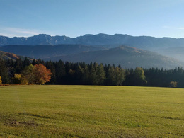
panoramic view: Great panorama
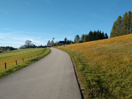
Paths covering:
Asphalt, Gravel, Street, Other
powered by TOURDATA
Take-off altitude: 540 m | Highest point: 945 m | Lowest point: 469 m | Altitude difference: 1,488 m | Total distance: 60.58 km | Travel time: 5 hours 30 minutes
Start of the tour at the church parking place in Abtsdorf.
We follow the forest road until we reach the Großalmstraße. We turn left in the Großalmstraße, passing the Taferlklaussee, till the highest point and on the other side down to the guest house Kienklause.
After km 57 we have reached the guest house Kienklause here you can finish the first day and overnight, or you drive right into the old Kienklausstraße and follow it to Seefeld and end there the day stage.
Stop for refreshments:
• Starting point: Gastronomy in Abtsdorf and in Seefeld
• On the route: guest houses in Seewalchen and Schörfling, guest house Bachschmiede, guest house Födinger, guest house Kogler am Gahberg, gastronomy in Neukirchen, guest house Kienklause
Start of the tour at the church parking place in Abtsdorf.
- From the parking place we turn left direction to Palmsdorf.
- After aprox. 400m turn right at the fire station.
- Km 1,4 left, follow the cycleway R2 through Palmsdorf. After another 300m we cross the railway tracks and then the main road. We follow the cycleway R2 direction Seewalchen.
- At km 2,4 left, continue on R2.
- km 2,9 follow the R2.
- After 4 km we come to a crossroad which we cross and follow the R2.
- Km 5,4 further on R2 direction to Schörfling.
- After 7,9 km we arrive to the main road and follow the R2 to the right towards Seewalchen.
- Through Seewalchen likewise follow the R2, after 9,7 km turn left.
- After 10,3 km we get to a crossroad with traffic lights, we turn right and drive over the Ager bridge. After 200m turn right again into Schörfling. Follow the R2 signage direction to Aurach. In the village before the church turn right and follow the R2.
- At km 11,5 left, continue on R2.
- Km 12 cross the federal road and follow the MTB signage direction to Hongar-Gahberg.
- ATTENTION After km 13,7 we do not follow the signs to Hongar-Gahberg anyomer but continue straight ahead. Signage direction to Poinerhaus.
- Km 14,7 we turn left into Holzbauernstraße and follow the MTB signage direction to Gahberg.
- After 17,2 km left direction to Gahberg.
- Km 17,7 at the crossroad right direction to Gahberg.
- Km 19,8 turn right into the asphalt road. We continue on this road passing the Gahbergkirche (chapel) and the Gasthaus Kogler. The road leads us further into the valley direction Weyregg.
- After the descent, we reach the village of Bach. In the village of Bach we turn left before the brook forge. Signage Gasthaus Födinger, or rather MTB route Langbathseerunde NR. 54.
- At km 31,9 we continue driving straight ahead. Signage towards Hochkreut Tierpark, circular route lower Talbergstraße.
- After 33,8 km, keep right twice in a row, always in the direction of Hochkreut Tierpark.
- Km 35,5 keep right direction to Tierpark Hochkreut, Reindlmühl.
- At km 37,5 we turn left at the asphalt street and we drive downhill towards Reindlmühl.
- Km 40 turn right into the main road direction to Neukirchen.
- Km 41 at the big crossroad, turn right direction to Steinbach am Attersee, or rather Taferklaussee, Hochlecken lift.
- Km 45 leave the federal road and turn left into the forest road direction to Langbathseen, signage Windlegern-Neukirchen. Just in front of the Nadasdy Klause.
- At km 46 turn right direction to Langbathseen.
- After km 48,6 turn left towards Langbathsee, Schafluckensteig. Short slide.
- After the slide and a short descent, we reach a forest road at km 48,8 and drive right uphill.
- ATTENTION If you still have strength and time here, turn left and take the round of Langbathseen. Highly recommended.
- At km 50 continue right, signage large plains.
We follow the forest road until we reach the Großalmstraße. We turn left in the Großalmstraße, passing the Taferlklaussee, till the highest point and on the other side down to the guest house Kienklause.
After km 57 we have reached the guest house Kienklause here you can finish the first day and overnight, or you drive right into the old Kienklausstraße and follow it to Seefeld and end there the day stage.
Stop for refreshments:
• Starting point: Gastronomy in Abtsdorf and in Seefeld
• On the route: guest houses in Seewalchen and Schörfling, guest house Bachschmiede, guest house Födinger, guest house Kogler am Gahberg, gastronomy in Neukirchen, guest house Kienklause
further information:
- Possible accommodation
- Board possible
details mountainbike
- Riding technique: difficult
As this tour does not lead to the Hochgebirge, it is also very easy to ride in spring and autumn.
Accessibility / arrival
Start of this tour is by the catolic church in Abtsdorf (about 1 km away from Attersee am Attersee)
- Parking space: 5
- All weather
- Suitable for groups
- Suitable for seniors
- Suitable for single travelers
- Suitable for friends
- Suitable for couples
- Spring
- Summer
- Autumn
Please get in touch for more information.
Attergaustraße 55
4880 St. Georgen im Attergau
Phone +43 7666 7719 - 0
E-Mail info@attersee.at
Web attersee-attergau.salzkammergut.at
Web www.asc-attersee.at
https://attersee-attergau.salzkammergut.at
http://www.asc-attersee.at
http://www.asc-attersee.at
Interactive elevation profile
Create PDF
Tour-Details
Starting place: 4864 Attersee am Attersee
Destination: 4853 Steinbach am Attersee
duration: 6h 2m
length: 65,9 km
Altitude difference (uphill): 1.916m
Altitude difference (downhill): 1.963m
Lowest point: 470m
Highest point: 939m
difficulty: difficult
condition: difficult
panoramic view: Great panorama
Paths covering:
Asphalt, Gravel, Street, Other
powered by TOURDATA