

Around the Höllengebirge - Mountainbiketour


- Flatly
Interactive elevation profile
Create PDF
Tour-Details
Starting place: 4853 Steinbach am Attersee
Destination: 4853 Steinbach am Attersee
duration: 5h 34m
length: 64,5 km
Altitude difference (uphill): 1.535m
Altitude difference (downhill): 1.539m
Lowest point: 434m
Highest point: 906m
difficulty: medium
condition: difficult
panoramic view: Great panorama
Paths covering:
Asphalt, Hiking trail
powered by TOURDATA
Around the Höllen mountain range with the mountain bike. Either from Steinbach am Attersee or from Ebensee.
From the village center Steinbach the road leads us high above the shore of the Attersee to Forstamt, where we have to descend to the B152. In Weißenbach, however, our path branches off to the left after the Hotel Post into the valley of the same name. We can leave the federal road together with the cycle track R15 after approx. 500 meters, because the bike path was created a few years ago here on its own track. This is the way to a comfortable wheeled gravel road along the Weißenbach, which invites you to a refreshing bath in the summer, upstream, before we have to change back to the road after about 6 km. (Further expansion of the R15 to Bad Ischl is planned). A little later, the waterside of the flat Weißenbach valley is reached, and we quickly descend to the valley of the river Traun. Here, however, we do not choose the R2 direction Ebensee along the federal road, but drive a short distance on the right upstream and then on a bridge that is already clearly visible over the river Traun. On low-traffic side roads and gravel roads (signposted Trans-Salzkammergut) it is always on the right of the river and the railway line as far as Lahnstein, where we change the side and from there together with the R2 via Plankau Ebensee, where a rest is offered before the much more demanding second part of the Hellbirge circumnavigation.
In the center of Ebensee, turn left towards Langbathseen and we reach the valley station of the Feuerkogel cable car. After a further 4 km on the Landesstraße we turn left signage Langbathseen-Runde to a gravel road, which leads us over wavy terrain to the idyllically situated Langbathseen. The back of the two lakes can also be circumnavigated before the first real downhill climb, the ascent to Lueg (830m) awaits us. From there on, the unique trail section of the round become shortly very rocky downhill (eventualy pushing) and following an enjoyable departure to the Großalm-Straße
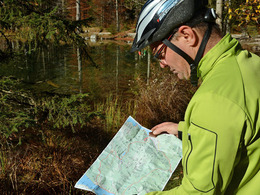
Conditionally weaker bikers can shorten from here over the Taferlklause on the Landessstraße. All the others drive briefly towards Neukirchen, before the signage points sharply to the left into the valley of the Weidensbach. First gentle ascending, but then crisp and strenuous it goes on good gravel 300 meters to the saddle of the Praterstern at 907 meters, the highlight of the tour. From there, at a rapid pace, down to the main road and then from the Kienklause down the old Landesstrasse through the wild-romantic Kienbach valley until we reach the Lake Attersee again. From there it is only 1 km and a last short climb to the village center of Steinbach.
From the village center Steinbach the road leads us high above the shore of the Attersee to Forstamt, where we have to descend to the B152. In Weißenbach, however, our path branches off to the left after the Hotel Post into the valley of the same name. We can leave the federal road together with the cycle track R15 after approx. 500 meters, because the bike path was created a few years ago here on its own track. This is the way to a comfortable wheeled gravel road along the Weißenbach, which invites you to a refreshing bath in the summer, upstream, before we have to change back to the road after about 6 km. (Further expansion of the R15 to Bad Ischl is planned). A little later, the waterside of the flat Weißenbach valley is reached, and we quickly descend to the valley of the river Traun. Here, however, we do not choose the R2 direction Ebensee along the federal road, but drive a short distance on the right upstream and then on a bridge that is already clearly visible over the river Traun. On low-traffic side roads and gravel roads (signposted Trans-Salzkammergut) it is always on the right of the river and the railway line as far as Lahnstein, where we change the side and from there together with the R2 via Plankau Ebensee, where a rest is offered before the much more demanding second part of the Hellbirge circumnavigation.
In the center of Ebensee, turn left towards Langbathseen and we reach the valley station of the Feuerkogel cable car. After a further 4 km on the Landesstraße we turn left signage Langbathseen-Runde to a gravel road, which leads us over wavy terrain to the idyllically situated Langbathseen. The back of the two lakes can also be circumnavigated before the first real downhill climb, the ascent to Lueg (830m) awaits us. From there on, the unique trail section of the round become shortly very rocky downhill (eventualy pushing) and following an enjoyable departure to the Großalm-Straße
Conditionally weaker bikers can shorten from here over the Taferlklause on the Landessstraße. All the others drive briefly towards Neukirchen, before the signage points sharply to the left into the valley of the Weidensbach. First gentle ascending, but then crisp and strenuous it goes on good gravel 300 meters to the saddle of the Praterstern at 907 meters, the highlight of the tour. From there, at a rapid pace, down to the main road and then from the Kienklause down the old Landesstrasse through the wild-romantic Kienbach valley until we reach the Lake Attersee again. From there it is only 1 km and a last short climb to the village center of Steinbach.
further information:
- Flatly
details mountainbike
- Riding technique: medium
- Suitable for friends
- Spring
- Summer
- Autumn
Please get in touch for more information.
Steinbach 5
4853 Steinbach am Attersee
Phone +43 7666 7719 - 60
E-Mail info.steinbach@attersee.at
Web attersee-attergau.salzkammergut.at
https://attersee-attergau.salzkammergut.at
You can also visit us on
Visit us on Facebook Visit our videochannel on YouTube WikipediaInteractive elevation profile
Create PDF
Tour-Details
Starting place: 4853 Steinbach am Attersee
Destination: 4853 Steinbach am Attersee
duration: 5h 34m
length: 64,5 km
Altitude difference (uphill): 1.535m
Altitude difference (downhill): 1.539m
Lowest point: 434m
Highest point: 906m
difficulty: medium
condition: difficult
panoramic view: Great panorama
Paths covering:
Asphalt, Hiking trail
powered by TOURDATA