

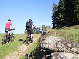
Kampursprung Tour No. M8


- culturally interesting
- Flatly
Interactive elevation profile
Create PDF
Tour-Details
Path number: M8
Starting place: 4252 Liebenau
Destination: 4252 Liebenau
duration: 1h 9m
length: 15,0 km
Altitude difference (uphill): 300m
Lowest point: 862m
Highest point: 976m
difficulty: medium
condition: medium
panoramic view: Some Views
Paths covering:
Asphalt, Hiking trail
powered by TOURDATA
A very beautiful tour taking you to the source of the Kamp (Kamp river) on your bike. You are headed north to the town centre of Liebenau on your bike. The first highlight of this tour is the source of the Kamp, bordering the Waldviertel. This is where the "Große Kamp“ has its source. On a stretch of 11 kilometres, it constitutes the border between Upper and Lower Austria and after 153 km, it flows into the Donau (Danube) near Altenwörth. After riding into the Waldviertel from the town of Hirschau over the Kamp and back, the tour will take you to the towns of Schanz and Reitern back to the starting point in Liebenau.
Accessibility / arrival
From Linz coming by car: via A7 and L1472
1 h 4 min, 57.4 km
No parking fees
- Suitable for groups
- Suitable for teenagers
- Suitable for single travelers
- Suitable for friends
- Suitable for couples
- Spring
- Summer
- Autumn
Please get in touch for more information.
Markt 41
4252 Liebenau
Phone +43 7953 8111
E-Mail office@muehlviertleralm.at
Web www.muehlviertleralm.at
Web www.tourdealm.at
http://www.muehlviertleralm.at
http://www.tourdealm.at
http://www.tourdealm.at
Interactive elevation profile
Create PDF
Tour-Details
Path number: M8
Starting place: 4252 Liebenau
Destination: 4252 Liebenau
duration: 1h 9m
length: 15,0 km
Altitude difference (uphill): 300m
Lowest point: 862m
Highest point: 976m
difficulty: medium
condition: medium
panoramic view: Some Views
Paths covering:
Asphalt, Hiking trail
powered by TOURDATA