

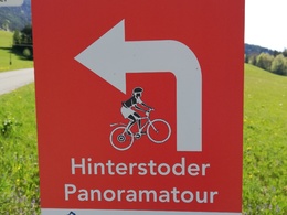
Hinterstoder Panorama Tour MTB4


- Flatly
Interactive elevation profile
Create PDF
Tour-Details
Path number: MTB4
Starting place: 4573 Hinterstoder
Destination: 4573 Hinterstoder
duration: 2h 1m
length: 19,5 km
Altitude difference (uphill): 550m
Altitude difference (downhill): 550m
Lowest point: 531m
Highest point: 836m
difficulty: medium
condition: medium
panoramic view: Great panorama
Paths covering:
Asphalt, Gravel
powered by TOURDATA
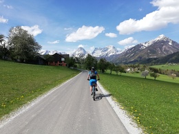
The secret in the beautiful Stodertal!
Short but crisp bike tour over the L155 out of the valley, then over the Tambergau up to Vorderstoder and from there on the other side back to Hinterstoder.
Route:
Hinterstoder - out of the valley via the L155 - at the Sagmeisterbrücke bus stop, turn right towards Sonnleiten and across the Vordertambergau to the local square in Vorderstoder. Here you drive a little bit on the main road towards Roßleithen, at the bus stop Käserei turn right towards Schafferteich (detour on the MTB3 to Schafferteich possible). Follow the winter hiking trail to the right in the direction of Hinterstoder and via Hutterer Seite - Wartegg - back to the large cable car parking lot to Hinterstoder.
ATTENTION: There is a route change between Wartegg and Spintriegl!
At the wood storage, turn right and follow the signs MTB4 in the direction of Landhotel Gressenbauer, from here the route back to the cable car parking lot is the same as route MTB3.
Starting point: Parking lot of the cable car in Hinterstoder
Destination: Parking lot of the cable car in Hinterstoder
further information:
- Flatly
- Board possible
details mountainbike
- Riding technique: medium
Cycling and mountain biking is allowed from April 15th to October 31st 2 hours after sunrise to 1 hour before sunset and is only allowed on marked routes. Some bike paths are also designated as hiking trails or bridle paths. Always count on oncoming hikers or riders!
Accessibility / arrival
Travel directly to the center of Hinterstoder, where this tour starts and ends. You can park for free at the large cable car parking lot at the entrance to the village.
- Suitable for seniors
- Suitable for single travelers
- Suitable for friends
- Suitable for couples
- Spring
- Summer
- Autumn
Please get in touch for more information.
Hinterstoder 38
4573 Hinterstoder
Phone +43 7564 5263
Fax machine +43 7564 5263 - 30
E-Mail hinterstoder@pyhrn-priel.net
Web www.urlaubsregion-pyhrn-priel.at
https://www.urlaubsregion-pyhrn-priel.at

")
")
Interactive elevation profile
Create PDF
Tour-Details
Path number: MTB4
Starting place: 4573 Hinterstoder
Destination: 4573 Hinterstoder
duration: 2h 1m
length: 19,5 km
Altitude difference (uphill): 550m
Altitude difference (downhill): 550m
Lowest point: 531m
Highest point: 836m
difficulty: medium
condition: medium
panoramic view: Great panorama
Paths covering:
Asphalt, Gravel
powered by TOURDATA